Beveridge Reef
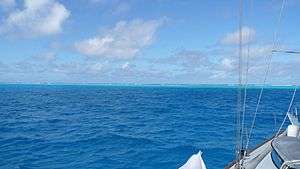
looking north across lagoon, from position after entrance
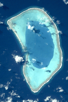
Beveridge Reef seen from space.
Beveridge Reef is a submerged atoll located in the Exclusive Economic Zone of Niue, approximately 130 miles (209 km) from Niue and 600 miles (966 km) from the Cook Islands.[1][2][3] The reef is normally submerged,[4] with a small part is visible at low tide.[1][5] It has been the cause of several fishing boats running aground.
The wreck of the Nicky Lou of Seattle, a fiberglass hulled fishing vessel that ran aground on the reef, can be seen on the reef.[6]
Elsdon Best reported that "according to native tradition at Rarotonga, the Beveridge Reef was once a fine isle, with many coconut-palms growing thereon, but that it was swept bare by a fierce hurricane, which carried away both trees and soil, leaving nothing but the bare rock."[7]
References
- 1 2 South Pacific Commission (1992). The South Pacific Commission Fisheries Newsletter.
- ↑ John Robert Victor Prescott; Grant Boyes (2000). Undelimited Maritime Boundaries in the Pacific Ocean Excluding the Asian Rim. IBRU. pp. 14–. ISBN 978-1-897643-39-6.
- ↑ http://voices.nationalgeographic.com/2016/10/06/beveridge-reef-from-shallow-seas-to-darker-depths/
- ↑ A. G. Findlay (28 March 2013). A Directory for the Navigation of the Pacific Ocean, with Descriptions of Its Coasts, Islands, Etc.: From the Strait of Magalhaens to the Arctic Sea, and Those of Asia and Australia. Cambridge University Press. pp. 805–. ISBN 978-1-108-05973-2.
- ↑ P. J. Dalzell; G. L. Preston; SPC Fisheries Programme (1992). Deep reef slope fishery resources of the South Pacific: a summary and analysis of the dropline fishing survey data generated by the activities of the SPC Fisheries Programme between 1974 and 1988. South Pacific Commission.
- ↑ Miles Hordern (20 May 2014). Sailing the Pacific: A Voyage Across the Longest Stretch of Water on Earth, and a Journey into Its Past. St. Martin's Press. pp. 247–. ISBN 978-1-4668-7196-0.
- ↑ Best, Elsdon (1922). Some aspects of Maori myth and religion. W.A.G. Skinner. p. 10. Retrieved 2011-10-11.
External links
This article is issued from
Wikipedia.
The text is licensed under Creative Commons - Attribution - Sharealike.
Additional terms may apply for the media files.