Bettié
| Bettié | |
|---|---|
| Town, sub-prefecture, and commune | |
 Bettié Location in Ivory Coast | |
| Coordinates: 6°4′N 3°24′W / 6.067°N 3.400°WCoordinates: 6°4′N 3°24′W / 6.067°N 3.400°W | |
| Country |
|
| District | Comoé |
| Region | Indénié-Djuablin |
| Department | Bettié |
| Population (2014)[1] | |
| • Total | 24,983 |
| Time zone | UTC+0 (GMT) |
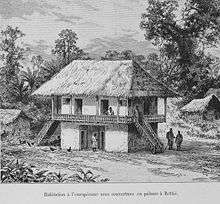
European dwelling in Bettié, 1892
Bettié is a town in south-eastern Ivory Coast. It is a sub-prefecture of and seat of Bettié Department in Indénié-Djuablin Region, Comoé District. Bettié is also a commune. The town lies on the east bank of the river that forms the boundary between Comoé and Lagunes Districts.
References
- ↑ "Côte d'Ivoire". geohive.com. Retrieved 8 December 2015.
Regional seat: Abengourou | ||
| Abengourou Department |  | |
| Agnibilékrou Department | ||
| Bettié Department | ||
* also a commune | ||
This article is issued from
Wikipedia.
The text is licensed under Creative Commons - Attribution - Sharealike.
Additional terms may apply for the media files.