Betafo
| Betafo | |
|---|---|
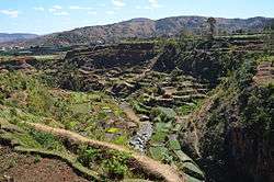 fields near Betafo | |
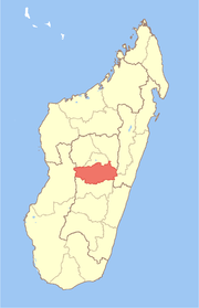
 Betafo Location in Madagascar | |
| Coordinates: 19°50′24″S 46°51′18″E / 19.84000°S 46.85500°ECoordinates: 19°50′24″S 46°51′18″E / 19.84000°S 46.85500°E | |
| Country |
|
| Region | Vakinankaratra |
| District | Betafo District |
| Elevation | 1,410 m (4,630 ft) |
| Population (2001)[1] | |
| • Total | 31,000 |
| Time zone | UTC3 (EAT) |
Betafo or Betafó ("many roofs") is a town and urban commune in Vakinankaratra Region, in the Central Highlands of Madagascar.
The town had an estimated population of 31,000 in 2001 [1] and is the administrative centre of Betafo District.
Geography
Betafo is situated at an altitude of 1,410 metres (4,630 ft) above sea level, in the central highlands of Madagascar. The town lies along the RN34 national road, 191 km (119 mi) from the country's capital, Antananarivo.
Ecclesiastical history
[2]On 1913.05.15 it became the seat of Catholic missionary pre-diocesan jurisdiction, the Apostolic Prefecture of Betafó, which was promoted on 1918.08.24 as Apostolic Vicariate of Betafó, but on 1921.01.10 that was renamed as Apostolic Vicariate of Antsirabé (meanwhile a diocese) when the seat was moved there.
UNESCO World Heritage Site
The irrigated rice paddies of the area are emblematic of this technology throughout the Malagasy highlands and were nominated to the Tentative List of UNESCO World Heritage Sites in Madagascar in 1997.[3]
References
- 1 2 Cornell University. "The Commune Census of by the Ilo program of Cornell University in collaboration with FOFIFA and INSTAT".
- ↑ http://www.gcatholic.org/dioceses/diocese/ants1.htm
- ↑ UNESCO. "World Heritage Convention: Madagascar". Archived from the original on April 24, 2011. Retrieved April 25, 2011.
Sources and external links
| Wikimedia Commons has media related to Betafo. |