Berkeley Pier
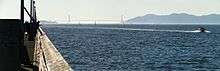
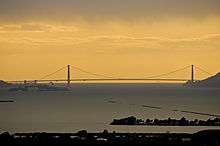
The Berkeley Pier is in Berkeley, California. When constructed in 1926, the pier extended 3.5 miles (5.6 km) [1] into San Francisco Bay from the end of University Avenue. Due to extensive filling of the bay and the creation of the Berkeley Marina, it presently extends only 2.5 miles (4.0 km). Since 1937, only the first 3,000 feet (910 m) were maintained and open to the public until July 2015, when public access was closed due to safety concerns.
History
In the mid-19th century, two private wharves were built along the Berkeley waterfront. One was located at the foot of Addison Street one block south of University Avenue and served the Standard Soap Company, a major regional soap-making factory. The other, the Jacobs and Heywood Wharf, was located several blocks north of University Avenue at the foot of Delaware Street, used as a general freight transshipment point.
In 1909, the City built a municipal wharf at the foot of University Avenue.[2] This pier was intended for a commuter ferry which never materialized, and the pier was instead used mainly for freight.
In 1925, the Golden Gate Ferry Company announced its plans to build a new ferry pier for its proposed service between Berkeley and San Francisco.[3]
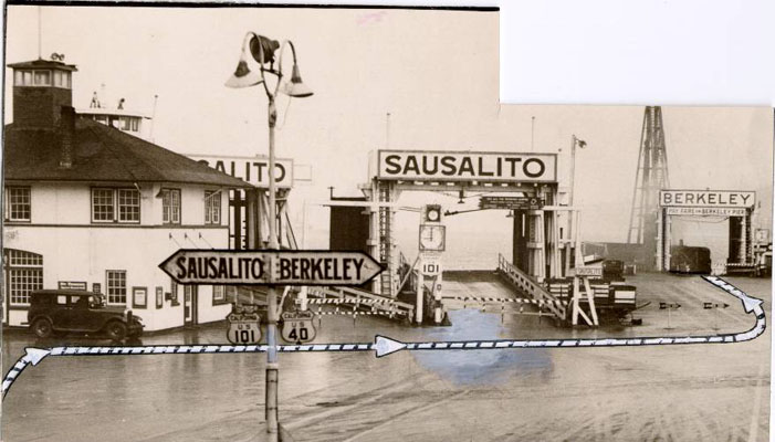
Starting in 1926, the Golden Gate Ferry Company began construction of the Berkeley Pier. It was also built out from the foot of University Avenue, extending about 3.5 miles (5.6 km) into the Bay (measured from the original shoreline). On June 16, 1927, auto ferry service began [4][5][6][7] between the Berkeley Pier and the Hyde Street Pier in San Francisco, a pier shared with the Sausalito ferry.[8] In early 1929, the Golden Gate Ferry Company merged with the competing auto ferry system of the Southern Pacific railroad. On May 1, 1929, ferry service to San Francisco from the Berkeley Pier was taken over by the new "Southern Pacific-Golden Gate Ferries, Ltd."[9]
At the beginning of service, before the merger with SP, four specially-built diesel ferry boats ran every 15 minutes between Berkeley and San Francisco via the pier: The Golden Bear, the Golden Poppy, the Golden State, and the Golden Dawn, all painted yellow.[10] Upon merging with the SP, the boats were all re-painted in the standard Southern Pacific maritime white.
In August of 1928, radio station KTAB, associated with the Pickwick Broadcasting Corporation, began construction of its broadcasting facilities including a large antenna tower at the pier.[11]
Between 1926 and 1937, the Pier served as an integral part of the Lincoln Highway (the first road across America), and then subsequently U.S. Route 40. A two-lane road ran the entire length to a ferry dock at the end of the pier. The ferry line shut down on October 16, 1937,[12] 11 months after the Bay Bridge opened to auto traffic.
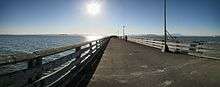
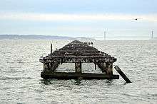
Upon the cessation of ferry service, the portion of the pier closest to shore was converted to recreational use, mainly fishing.[13] The remaining portion of the pier was left to decay, and is still visible, but inaccessible due to a barrier. There is a gap of about fifty feet at the end of the current pier to allow the passage of small boats. In 2007, proposals were considered to start a new ferry service using a terminal near the pier.[14]
In July 2015, the entrance to the pier was fenced off and access was forbidden due to safety concerns after severe weathering and corrosion was discovered in the concrete and iron rebar supporting the pier.[15][16]
Popular culture
The East Bay punk band Tilt has a song titled "Berkeley Pier" that is a punk rock love song. The song describes the singer's experiences with her ex-lover on the pier and then seeing a "young Romeo, hand in hand, with his punk rock Juliette" while walking on the pier.[17]
See also
References
- ↑ Berkeley Daily Gazette, May 7, 1927
- ↑ Third Annual Report of the City Manager, 1925-26, City of Berkeley, p.31
- ↑ Sausalito News, June 27, 1925
- ↑ Fourth Annual Report of the City Manager, 1926-27, City of Berkeley, p.16
- ↑ Berkeley Daily Gazette, May 7, 1927
- ↑ Berkeley Daily Gazette, May 27, 1927
- ↑ Berkeley Daily Gazette, June 16, 1927
- ↑ http://webbie1.sfpl.org/multimedia/sfphotos/AAC-2256.jpg
- ↑ Red Trains in the East Bay, by Robert Ford, pp.174-79, Interurbans Publications, 1977
- ↑ Berkeley Daily Gazette, June 17, 1927
- ↑ Sausalito News, August 31, 1928
- ↑ Red Trains in the East Bay, by Robert Ford, p.201, Interurbans Publications, 1977.
- ↑ "Pier Fishing in California - Berkeley Pier". pierfishing.com. Retrieved 2015-11-17.
- ↑ San Francisco Chronicle "BERKELEY / Public hearing on new ferry terminals" 5 3 2007" recovered through EBBSCO's Australia New Zealand Reference Centre"
- ↑ "Historic Berkeley Pier Closes Due To Structural Damage". cbslocal.com. Retrieved 2015-11-17.
- ↑ Berkeley Daily Planet, Berkeley California. "Deteriorating Berkeley Pier May Need Major, Costly Repairs. Category: Page One from The Berkeley Daily Planet". berkeleydailyplanet.com. Retrieved 2015-11-17.
- ↑ http://www.metrolyrics.com/berkeley-pier-lyrics-tilt.html
External links
- Berkeley Marina and Pier
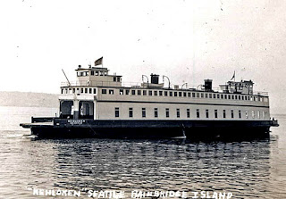
- Photograph of the ferry Golden Poppy
- Photograph of the ferry Kehloken, formerly the Golden State
37°51′46″N 122°19′03″W / 37.86283°N 122.3176°WCoordinates: 37°51′46″N 122°19′03″W / 37.86283°N 122.3176°W