Bergheider See
The Bergheider See, south of Finsterwalde near Lichterfeld in the county of Elbe-Elster in Germany, is a flooded pit from the former open cast mine of Klettwitz-Nord, northeast of the Lower Lusatian Heath. The lake was named after the old village of Bergheide, which had to be abandoned for the brown coal pit.
The flooding of the pit, under the direction of the LMBV mining company, began in September 2001 and ended in May 2014.[1][2] The lake is part of the Lusatian Lake District, but is isolated from the Lusatian Lake Chain as it is 20 kilometres away from the waterways linking the other lakes. The Bergheider See has a surface area of about 320 ha. On the Lichterfeld shore (north shore) are bathing facilities.[3] Die anderen Uferflächen sind dem Naturschutz vorbehalten. Dort bestehen Sperrbereiche der LMBV.
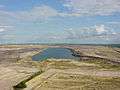 The Bergheider See, the Klettwitz wind park and, in the distance, the Lusatian Mountains (2004)
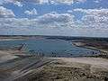 View of the F60 Visitor Mine by the clearly larger lake (2007)
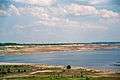 Three years later the shore zone began to fill up (2010)
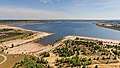 Bergheider See (2015)
In 2002, the F60 Visitor Mine opened on the northern shore of the lake. The show mine has the largest movable piece of mining equipment in the world, 502 metres long. It has been made accessible for visitors. At the top it is 75 metres above the bottom. Together with the show mine, the lake is being converted into a recreation area with floating houses, a water sports centre and a holiday home park. The terrain is being used to stage events. The starting project for the scheme was the International Construction Exhibition of Prince Pückler Land from 2000 to 2010.
The newly renovated Landstraße L 60 from Lichterfeld to Lauchhammer, which runs past the Bergheider See, was closed in summer 2010 but reopened in December 2015.[4]
References
- ↑ Flutungstände auf www.lmbv.de retrieved 29 March 2015
- ↑ "Flutungsstand Brandenburgische Lausitz - LMBV". www.lmbv.de (in German). Retrieved 2016-11-20.
- ↑ Lausitzer Rundschau. "Erstmals Baden im Bergheider See beim Lichterfelder Festival". www.lr-online.de (in German). Retrieved 2016-11-20.
- ↑ Lausitzer Rundschau. "Durststrecke vorbei: Über die L 60 wieder flott zur F 60". www.lr-online.de (in German). Retrieved 2016-11-20.
External links
| Wikimedia Commons has media related to Bergheider See. |
- Pressemitteilung der Lausitzer und Mitteldeutsche Bergbau-Verwaltungsgesellschaft mbH (LMBV) zum Beginn der Flutung des Bergheider Sees (21. September 2001)
- Website of the show mine
Coordinates: 51°34′17″N 13°47′24″E / 51.57139°N 13.79000°E