Belleau, Lincolnshire
| Belleau | |
|---|---|
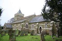 Church of St John Baptist, Belleau | |
 Belleau Belleau shown within Lincolnshire | |
| OS grid reference | TF402786 |
| • London | 120 mi (190 km) S |
| District | |
| Shire county | |
| Region | |
| Country | England |
| Sovereign state | United Kingdom |
| Post town | Lincoln |
| Postcode district | LN13 |
| Police | Lincolnshire |
| Fire | Lincolnshire |
| Ambulance | East Midlands |
| EU Parliament | East Midlands |
| UK Parliament | |
Belleau is a hamlet and civil parish in the East Lindsey district of Lincolnshire, England. It is situated approximately 7 miles (11 km) south-east from Louth, and 4 miles (6 km) north-west from Alford. The Bellau parish includes the hamlet of Claythorpe.
According to the 2001 Census Belleau had a population of 18 in 8 households.[1] At the time of the 2011 census the population remained fewer than 100 and was included in the civil parish of Authorpe.
The village name is taken from the spring of the rivulet Eau which rises in the village.[2]
The Grade II listed parish church of Belleau is dedicated to St John the Baptist.[3] The church was almost entirely rebuilt in 1862. Near the church are the remains of an old manor house, the former home of the Earls of Lindsey.[2][4] Other Bellau listed buildings are a pigeoncote[5] and barn[6] at Manor Farm.
A notable Belleau resident was the Puritan leader Henry Vane the Younger.
References
- ↑ "Neighbourhood statistics". 2001 census. Office for national statistics. Retrieved 20 April 2013.
- 1 2 Cox, J. Charles (1916) Lincolnshire pp. 58-59; Methuen & Co. Ltd
- ↑ Historic England. "Church of St John the Baptist (1063630)". National Heritage List for England. Retrieved 28 June 2011.
- ↑ "Bellau", Genuki.org.uk; retrieved 28 June 2011
- ↑ Historic England. "Pigeoncote at Manor Farm (1063631)". National Heritage List for England. Retrieved 28 June 2011.
- ↑ Historic England. "Barn at Manor Farm (1063632)". National Heritage List for England. Retrieved 28 June 2011.
External links

- "History of Belleau, in East Lindsey and Lincolnshire". A Vision of Britain through Time. GB Historical GIS / University of Portsmouth. Retrieved 5 October 2013.
England Portal | |
| Unitary authorities | |
| Boroughs or districts | |
| Major settlements |
|
| Topics | |