Belgium–Netherlands border
The Belgium–Netherlands border separates Belgium and the Netherlands and is 450 km long.
Belgium and the Netherlands are part of the Schengen Area. This means there are no permanent border controls at this border.
On the Belgian side, the border is shared by four Flemish provinces (out of the five in the Flemish Region). From west West Flanders, East Flanders, Antwerp and Limburg (Belgium). A small part is shared by the Walloon province of Liège, which also includes the German-speaking East Cantons. At the Dutch side, the border is shared by three provinces: Zeeland, North Brabant and Limburg.
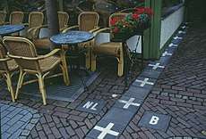
Between Belgian and Dutch Limburg, the border is mostly formed by the Meuse (Maas) river. The other parts of the border is mostly on land. The city of Baarle-Hertog forms a Belgian exclave in the Netherlands. The border is complicated there, with Dutch exclaves inside it.
The eastern end point is the tripoint (together with Germany) at Vaalserberg.
History
During the First World War, an electric fence was installed along the border by the German military, called the Wire of Death.
Border changes
Two border changes have occurred in recent history with regard to the Belgium–Netherlands border.
See also
| Wikimedia Commons has media related to Borders of Belgium-Netherlands. |
References
- ↑ "Netherlands and Belgium to end lawless border oddity by swapping land peacefully". The Washington Post. November 29, 2016.