Belá (river)
| Belá | |
|---|---|
.jpg) | |
| Physical characteristics | |
| Main source | High Tatra |
| River mouth |
Váh in Liptovský Hrádok 49°02′06″N 19°42′36″E / 49.0349°N 19.7101°ECoordinates: 49°02′06″N 19°42′36″E / 49.0349°N 19.7101°E |
| Length | 22 km (14 mi) |
| Basin features | |
| Progression | Váh→ Danube→ Black Sea |
The Belá (Hungarian: Béla-patak), 22 kilometres (14 mi) in length, is a mountainous stream draining the headwaters of the Váh River basin in Tatra National Park, northern Slovakia.[1] It is a right tributary, into which it flows at the town of Liptovský Hrádok. The Belá itself is formed by two tributaries, the streams Tichý potok and Kôprovský potok, whose sources are in the High Tatra mountains, and which have their confluence near Podbanské, part of the town of Vysoké Tatry.
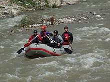
Rafting on the Belá River (June 2010)
References
- ↑ Pekárová P, Miklánek P (2011). "Long-term trend and multi-annual variability of water temperature in the pristine Bela River basin (Slovakia)". Journal of Hydrology. 400: 333–340. Bibcode:2011JHyd..400..333P. doi:10.1016/j.jhydrol.2011.01.048.
- ↑ rivers.raft.cz Archived March 28, 2013, at the Wayback Machine., retrieved 17 May 2012
This article is issued from
Wikipedia.
The text is licensed under Creative Commons - Attribution - Sharealike.
Additional terms may apply for the media files.