Beebe Mountain
| Beebe Mountain | |
|---|---|
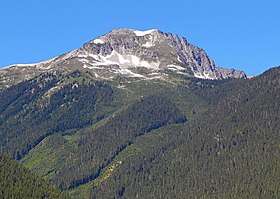 Beebe Mountain seen from the east | |
| Highest point | |
| Elevation | 7,416 ft (2,260 m) [1] |
| Prominence | 1,056 ft (320 m) [1] |
| Isolation | 1.42 mi (2.29 km) [1] |
| Coordinates | 48°39′47″N 120°55′27″W / 48.66306°N 120.92417°WCoordinates: 48°39′47″N 120°55′27″W / 48.66306°N 120.92417°W [1] |
| Geography | |
 Beebe Mountain Location of Beebe Mountain in Washington  Beebe Mountain Beebe Mountain (the US) | |
| Location | Whatcom, Washington, United States |
| Parent range | North Cascades |
| Topo map | USGS Crater Mountain |
| Climbing | |
| Easiest route | Scrambling |
Beebe Mountain is a summit in the Cascade Range in the U.S. state of Washington. It is located on the border of North Cascades National Park. The mountain's name honors Frank Beebe who worked for the Forest Service and maintained a cabin near the base of the mountain in the 1920s.[2] Precipitation runoff on the mountain drains into Ross Lake via Granite Creek and Panther Creek.
Climate
Beebe Mountain is located in the marine west coast climate zone of western North America.[2] Most weather fronts originate in the Pacific Ocean, and travel northeast toward the Cascade Mountains. As fronts approach the North Cascades, they are forced upward by the peaks of the Cascade Range (Orographic lift), causing them to drop their moisture in the form of rain or snowfall onto the Cascades. As a result, the west side of the North Cascades experiences high precipitation, especially during the winter months in the form of snowfall. During winter months, weather is usually cloudy, but, due to high pressure systems over the Pacific Ocean that intensify during summer months, there is often little or no cloud cover during the summer.[3] Because of maritime influence, snow tends to be wet and heavy, resulting in high avalanche danger.[3]
References
External links
- North Cascades National Park National Park Service