Beaver Slide
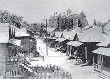
Beaver Slide or Beavers' Slide was an African American slum area near Atlanta University documented as early as 1882.[1] It was replaced by the University Homes public housing project in 1937, which was razed in 2008-9.
Charles Forrest Palmer, the man who organized the clearance of Beaver Slide and creation of University Homes, stated in his autobiographical book that Beaver Slide's name was due to James Beavers, Atlanta Chief of Police from 1911–1915, once observing the slum from a hillside, losing his footing and sliding down into the slum, thus: "Beavers' Slide".[2]
Beaver Slide was noted for its criminality.[3] In 1925 the area was targeted for a "cleanup" by city and university authorities.[4][5]
The area was celebrated musically in the "Beaver Slide Rag" by Peg Leg Howell And His Gang, 1927.[6]
It was finally razed to make for the University Homes public housing projects (William Augustus Edwards, architect), which opened in 1938.
University Homes was razed in 2008-9. As of January 2012 there has been no definitive announcement of what will be built on the land.[7]
References
- ↑ ""beaver slide" atlanta - Google Search". Google.com. Retrieved 11 July 2018.
- ↑ Charles Forrest Palmer. "Adventures of a Slum Fighter\website=Archive.org" (TXT). Retrieved 11 July 2018.
- ↑ Krakow, Kenneth K. (1975). Georgia Place-Names: Their History and Origins (PDF). Macon, GA: Winship Press. p. 16. ISBN 0-915430-00-2.
- ↑ Ferguson, Karen Jane (11 July 2018). "Black Politics in New Deal Atlanta". University of North Carolina Press. p. 189. Retrieved 11 July 2018 – via Google Books.
- ↑ "Atlanta Journal Constitution, Jan. 6, 1925". Pqasb.pqarchiver.com. Retrieved 11 July 2018.
- ↑ Max Haymes. "Background of Recorded Blues". Earlyblues.com\accessdate=11 July 2018.
- ↑ "Atlanta Housing". Atlantahousingauthority.blogpsot.com. Retrieved 11 July 2018.
External links
- Beaver Slide Rag (audio file)
33°44′51.68″N 84°24′36.22″W / 33.7476889°N 84.4100611°WCoordinates: 33°44′51.68″N 84°24′36.22″W / 33.7476889°N 84.4100611°W