Beaumont Cut
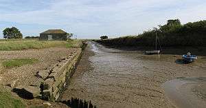
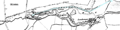
Beaumont Cut was a 1-kilometre-long (1,090 yd) canal linking Beaumont Quay, in the parish of Beaumont-cum-Moze, Tendring, Essex, England, with Hamford Water and the North Sea. It was opened in 1832 but fell into disuse and was closed at some time in the 1930s.
History
Archaeological studies suggest that the first canal on the site was built by the Romans, possibly in connection with salt extraction in the area. The nineteenth-century canal was constructed to serve the extensive coastal traffic between the agricultural hinterland of Essex and London, with produce and animal fodder being carried into the capital and manure for the fields as cargo for the return trip. The proprietors of the venture were the governors of Guy’s Hospital, who owned agricultural estates in the area.[1] They were granted supplies of stone from Old London Bridge (demolished in 1831) for the purpose. Two vessels, the Thames barges Beaumont Belle and The Gleaner, both owned by the tenant of one of the estates, were initially based on the canal, but general trade was accepted.
Beaumont Quay features in the 1939 novel Secret Water by Arthur Ransome.
Surviving structures
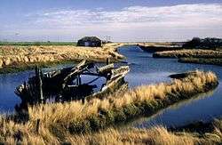
The line of the canal remains watered and is easily traceable. The quay at the western end of the canal – together with a disused barn and a lime kiln[3] – was made a scheduled ancient monument[4] and is now under the care of the parks department of Essex County Council.[1]
References
- 1 2 "Beaumont Quay". Victoria County History. Retrieved 5 February 2017.
- ↑ "Wreck, Beaumont Quay, Essex". National Monuments Record. English Heritage. Archived from the original on 2011-06-06. Retrieved 2009-04-03.
- ↑ "Beaumont Quay Limekiln". Geology Site Account. The Essex Field Club. Retrieved 5 February 2017.
- ↑ Historic England. "Beaumont Quay, Hamford Water: a 19th century quay and lime kiln (1020688)". National Heritage List for England.
External links
- Beaumont Quay and Cut, Unlocking Essex's Past, Essex County Council
- Beaumont-cum-Moze parish history
- Essex County Council local history page
- Image of restored west end of canal, from Pbase online image forum