Bearmouth, Montana
| Bearmouth, Montana | |
|---|---|
| Ghost town | |
 Bearmouth  Bearmouth | |
| Coordinates: 46°42′37″N 113°19′53″W / 46.71028°N 113.33139°WCoordinates: 46°42′37″N 113°19′53″W / 46.71028°N 113.33139°W[1] | |
| Country | United States |
| State | Montana |
| County | Granite |
| Elevation | 3,802 ft (1,159 m) |
Bearmouth was a trading post for the placer mining camps of Beartown, Garnet and Coloma, located in the hills north of Bearmouth. A pioneer family named Lannen operated the gold exchange and ferry boat across the Clark Fork River.[2]
Bearmouth was not a mining camp, but rather a town that depended on the survival of other towns that were mining camps, such as neighboring Garnet. During the late 19th century, enormously rich ores from Garnet came into Bearmouth to be shipped to smelters. When Garnet died, Bearmouth followed suit. The town, however, was also a main stop for stagecoaches on the old Mullan Road. As such, it had a beautiful two-storied, balconied inn for travelers to spend the night as well as a large livery stable, both of which still stand.
In September 1841, the intrepid Jesuit priest, Pierre Jean De Smet, traveled westward through this area on his way from St. Louis, to establish a mission for the Flathead Indians in the Bitterroot Valley.
The nearest town is Drummond, about eight miles to the east. The nearest large city is Missoula, about 40 miles to the west. The next large city to the east is Butte, 80 miles to the southeast.
The Hazel Marsh Papers is a collection of records from the many Lannen family businesses in Bearmouth. The post office, saloon, and general store ledger books are in the collection as well as financial records and legal documents from Christopher Lannen. School district records and voter registrations from Bearmouth are also in the collection. The collection also contains photographs and memorabilia and is located at the Maureen and Mike Mansfield Library, K. Ross Toole Archives, University of Montana.
Notes
- ↑ "Bearmouth". Geographic Names Information System. United States Geological Survey.
- ↑ Carkeek Cheney, Roberta (1983). Names on the Face of Montana. Missoula, Montana: Mountain Press Publishing Company. p. 5. ISBN 0-87842-150-5.
Municipalities and communities of Granite County, Montana, United States | ||
|---|---|---|
| Towns | 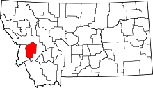 | |
| CDP | ||
| Unincorporated community | ||
| Ghost towns | ||
Missoula is about 43 miles to Orange St Exit on I-90 and Drummond is about 15 miles using the frontage road