Bazouges-sur-le-Loir
| Bazouges-sur-le-Loir | |
|---|---|
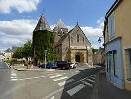 Church of Saint-Aubin | |
 Bazouges-sur-le-Loir Location within Pays de la Loire region  Bazouges-sur-le-Loir | |
| Coordinates: 47°41′25″N 0°10′07″W / 47.6903°N 0.1686°WCoordinates: 47°41′25″N 0°10′07″W / 47.6903°N 0.1686°W | |
| Country | France |
| Region | Pays de la Loire |
| Department | Sarthe |
| Arrondissement | La Flèche |
| Canton | La Flèche |
| Area1 | 29.90 km2 (11.54 sq mi) |
| Population (2006 [1])2 | 1,205 |
| • Density | 40/km2 (100/sq mi) |
| Demonym(s) | Bazougeois, Bazougeoise |
| Time zone | UTC+1 (CET) |
| • Summer (DST) | UTC+2 (CEST) |
| INSEE/Postal code | 72025 /72200 |
| Elevation | 22–99 m (72–325 ft) |
|
1 French Land Register data, which excludes lakes, ponds, glaciers > 1 km2 (0.386 sq mi or 247 acres) and river estuaries. 2 Population without double counting: residents of multiple communes (e.g., students and military personnel) only counted once. | |
Bazouges-sur-le-Loir is a former commune in the Sarthe department in the region of Pays-de-la-Loire in north-western France. On 1 January 2017, it was merged into the new commune Bazouges Cré sur Loir.[2]
See also
References
- ↑ http://www.insee.fr/fr/ppp/bases-de-donnees/recensement/populations-legales/departement.asp?dep=72#dep_B Populations légales 2006 publiées par l’INSEE le 1er janvier 2009
- ↑ Arrêté préfectoral 16 December 2016 (in French)
| Wikimedia Commons has media related to Bazouges-sur-le-Loir. |
This article is issued from
Wikipedia.
The text is licensed under Creative Commons - Attribution - Sharealike.
Additional terms may apply for the media files.