Bayuda volcanic field
| Bayuda volcanic field | |
|---|---|
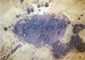 The volcanic field from space | |
| Highest point | |
| Elevation | 670 m (2,200 ft) [1] |
| Coordinates | 18°20′N 32°45′E / 18.33°N 32.75°ECoordinates: 18°20′N 32°45′E / 18.33°N 32.75°E [1] |
| Geography | |
 Bayuda volcanic field | |
| Geology | |
| Last eruption | 1,102 +- 48 years ago |
Bayuda volcanic field (also spelled Bayiuda[1]) is a volcanic field in Sudan, within the Bayuda Desert. It covers a surface of about 11 by 48 kilometres (6.8 mi × 29.8 mi) and consists of a number of cinder cones as well as some maars and explosion craters. These vents have erupted aa lava flows.
The field rises above a Precambrian-Paleozoic basement that may be a domal uplift. There is little known about the occurrence of volcanic eruptions, but the last eruption has been dated to 1,102 ± 48 years before present.
Geography and geomorphology
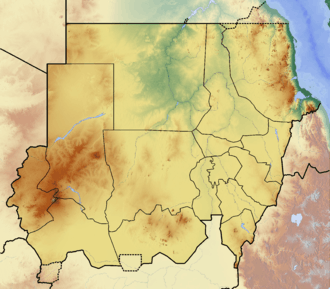
The volcanic field is located in the Bayuda Desert within the great bend of the Nile,[1] 300 kilometres (190 mi) north of Khartoum.[2] It lies 80 kilometres (50 mi) away from Merowe; there are wells at Abu Khorit and Sani[3] north of the volcanic field.[4] The field was discovered by aerial photography in 1920.[3]
Bayuda is an elongated volcanic field[1] with fresh volcanic features[3] extending over an area of 11 by 48 kilometres (6.8 mi × 29.8 mi) in northwesterly direction. Within this area, a number of volcanic vents within a narrow space have formed a continuous volcanic surface.[5] Some individual lava fields cover over 20 square kilometres (7.7 sq mi) of surface,[6] but surfaces of about 10 square kilometres (3.9 sq mi) are more typical.[7] There are usually only a few flows per vent, although they often have lobate structures. The surface of the lava flows has varying textures and often contains hills or ridges,[8] generally corresponding to aa lava.[9] Some flows reach lengths of 10 kilometres (6.2 mi).[10]
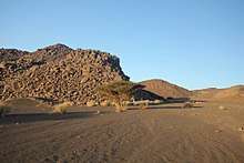
Cinder cones make up the bulk of the field,[1] of which there are about one hundred.[11] Usually the cones reach heights of over 400 metres (1,300 ft)[7] and are formed by volcanic ash, lapilli, lava bombs and scoria.[12] Many of these aside from pyroclastics also erupted lava flows[5] which then broke the crater rims.[1] Explosion craters[1] and sporadic maars are also found,[2] they are surrounded by tephra deposits which form low rims of pyroclastic material[13] and which also cover neighbouring volcanoes.[4] Individual vents form two separate alignments.[10]
Hosh ed Salam ("dark enclosure"[14]) crater is 500 metres (1,600 ft) deep and 1,300 metres (4,300 ft) wide,[1] other craters are Jebel Hebeish and El Muweilih which have formed shallow rises above the surrounding terrain and have cut into the basement rocks.[9] El Muweilih contains a salt lake after which it is named and which was used as a source of salt,[6] while Jebel El Abour contains a secondary cone. The Sergein hills and Jebel Azrub are composite volcanoes.[5] Angalafib, Goan and Jebel El Abour are also quite high.[6]
Pumice blocks from the field were found in Wadi Abu Dom,[3] and scoria downstream in the Nile.[14] Tephra identified in deposits on Mograt Island in the Nile most likely comes from this volcanic field.[15]
Geology
Volcanic activity has been taking place in Sudan since the Cretaceous, with most recent manifestations documented in the Bayuda volcanic field, Marra Mountains and Meidob volcanic field[3] both in Darfur,[16] and elsewhere in the form of small basaltic outcrops.[17] Bayuda is a small volcanic field in comparison to other African volcanic fields.[4] Volcanism at Bayuda may be associated with the Central African Shear Zone[18] and of Precambrian faults,[19] perhaps together with a mantle plume.[20]
The basement consists of granites of Precambrian and Paleozoic age[1] that belong to the Bayuda terrane,[2] which together with gneisses form a gentle pedeplain away from rougher landscape along the Nile.[21] Later on during the Cretaceous the Nubian Formation was laid down and there are hints of a domal uplift in the Bayuda area,[3] which probably predates the onset of volcanism and may have influenced the course of the Nile.[21] The existence of such a dome has been questioned, however.[22]
Composition
Bayuda has erupted basaltic rocks,[5] with most collected rocks belonging to an alkali basalt suite[23] although basanite, melabasanite, hawaiite and trachybasalt have been identified as well.[2][24] Phenocrysts include clinopyroxene and olivine.[23] Various xenoliths have been found, including garnet-containing clinopyroxenite, harzburgite, garnet hornblendite, amphibole-containing peridotite, olivine and spinel pyroxenite and websterite.[25]
In general the composition resembles that of other Sudanese-Egyptian volcanoes,[2] about two different magma families have been identified which originate from disparate mantle domains.[10] The total volume of the volcanic rocks is about 18 cubic kilometres (4.3 cu mi),[26] the rocks reach thicknesses of about 200 metres (660 ft) maximally.[4]
Eruptive history
Volcanic activity has been dated to 1.7 - 0.9 million years ago,[27] but it continued after the end of the latest wet period 5,000 years ago[1] as indicated by the uneroded state of some of the volcanoes[4] such as Hosh ed Salam.[28] The presence of maars and volcanoes with signs of phreatomagmatic activity may indicate activity during pluvials.[29] Volcanism at Bayuda commenced with isolated volcanoes. After a while, new edifices were constructed atop the older ones, influencing the morphology of the new volcanoes.[26]
The most recent lava flow was dated to less than 1,100 years before present,[1] with radiocarbon dating producing an age of 1,102 ± 48 years before present.[7] Aside from this date, however, there is little information on the timing of recent volcanic activity in the Bayuda volcanic field.[29]
References
- 1 2 3 4 5 6 7 8 9 10 11 12 "Bayuda Volcanic Field". Global Volcanism Program. Smithsonian Institution.
- 1 2 3 4 5 Lenhardt et al. 2018, p. 2.
- 1 2 3 4 5 6 Almond, Ahmed & Khalil 1969, p. 550.
- 1 2 3 4 5 Almond 1974, p. 346.
- 1 2 3 4 Almond, Ahmed & Khalil 1969, p. 557.
- 1 2 3 Almond, Ahmed & Khalil 1969, p. 561.
- 1 2 3 Almond, Kheir & Poole 1984, p. 235.
- ↑ Almond, Ahmed & Khalil 1969, p. 558.
- 1 2 Almond, Ahmed & Khalil 1969, p. 559.
- 1 2 3 Klitzsch & Thorweihe 1999, p. 129.
- ↑ Almond, Ahmed & Khalil 1969, p. 556.
- ↑ Lenhardt et al. 2018, p. 4.
- ↑ Lenhardt et al. 2018, p. 7.
- 1 2 Grabham 1920, p. 134.
- ↑ Dittrich, Annett; Neogi, Sayantani (27 January 2017). "Holocene Lake and Shallow Water Sediments at Mograt Island, Sudan". Studia Quaternaria. 34 (1): 17. doi:10.1515/squa-2017-0001.
- ↑ Grabham 1920, p. 135.
- ↑ Almond, Kheir & Poole 1984, p. 233.
- ↑ Pachur & Altmann 2006, p. 266.
- ↑ Pachur & Altmann 2006, p. 97.
- ↑ Klitzsch & Thorweihe 1999, p. 109.
- 1 2 Almond, Ahmed & Khalil 1969, p. 551.
- ↑ Almond, Kheir & Poole 1984, p. 242.
- 1 2 Almond, Ahmed & Khalil 1969, p. 564.
- ↑ Almond 1974, p. 350.
- ↑ Klitzsch & Thorweihe 1999, p. 132.
- 1 2 Almond, Ahmed & Khalil 1969, p. 563.
- ↑ Almond, Kheir & Poole 1984, p. 234.
- ↑ Pachur & Altmann 2006, p. 398.
- 1 2 Lenhardt et al. 2018, p. 12.
Sources
- Almond, D. C. (1 March 1974). "The composition of basaltic lavas from Bayuda, Sudan and their place in the cainozoic volcanic history of north-east Africa". Bulletin Volcanologique. 38 (1): 345–360. doi:10.1007/BF02599411. ISSN 0366-483X.
- Almond, D. C.; Ahmed, Farouk; Khalil, Badr Eldin (1 June 1969). "An excursion to the Bayuda volcanic field of Northern Sudan". Bulletin Volcanologique. 33 (2): 549–565. doi:10.1007/BF02596524. ISSN 0366-483X.
- Almond, D.C.; Kheir, O.M.; Poole, S. (January 1984). "Alkaline basalt volcanism in northeastern Sudan: a comparison of the Bayuda and Gedaref areas". Journal of African Earth Sciences (1983). 2 (3): 233–245. doi:10.1016/S0731-7247(84)80018-X. ISSN 0731-7247.
- Grabham, C. W. (1920). "The Bayuda Volcanic Field". Sudan Notes and Records. 3 (2): 133–136. JSTOR 41715760. (Subscription required (help)).
- Klitzsch, Eberhard; Thorweihe, Ulf (1999). Nordost-Afrika : Strukturen und Ressourcen : Ergebnisse aus dem Sonderforschungsbereich "Geowissenschaftliche Probleme in ariden und semiariden Gebieten" (in German) ([Online-Ausg.]. ed.). Weinheim: Wiley-VCH. ISBN 978-3-527-27724-7. (Subscription required (help)).
- Lenhardt, Nils; Borah, Suranjana B.; Lenhardt, Sukanya Z.; Bumby, Adam J.; Ibinoof, Montasir A.; Salih, Salih A. (March 2018). "The monogenetic Bayuda Volcanic Field, Sudan – New insights into geology and volcanic morphology". Journal of Volcanology and Geothermal Research. doi:10.1016/j.jvolgeores.2018.03.010. ISSN 0377-0273.
- Pachur, Hans-Joachim; Altmann, Norbert (2006). Die Ostsahara im Spätquartär (in German). SpringerLink. doi:10.1007/978-3-540-47625-2. ISBN 978-3-540-47625-2.