Bayeux (river)
| Bayeux | |
|---|---|
 | |
| Country | France |
| Physical characteristics | |
| River mouth |
Arc 43°30′3″N 5°30′59″E / 43.50083°N 5.51639°ECoordinates: 43°30′3″N 5°30′59″E / 43.50083°N 5.51639°E |
| Length | 10 km (6.2 mi) |
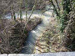
The Bayeux (Baion in Occitan) is a short stream[1] in the southeast of France. In the upper 2 kilometres (1.2 mi) of its course it is called Bayon. It runs from the Montagne Sainte-Victoire[2] to the Arc, near Meyreuil.
References
- ↑ "Le portail des territoires et des citoyens - Géoportail". Geoportail.fr. Retrieved 2013-12-05.
- ↑ "Erudit Article" (PDF). Erudit.org. Retrieved 2013-12-05.
External links
This article is issued from
Wikipedia.
The text is licensed under Creative Commons - Attribution - Sharealike.
Additional terms may apply for the media files.