Bayenthal

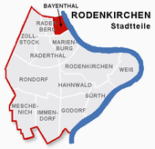
Bayenthal (German: Köln-Bayenthal) is a neighbourhood of Cologne, Germany and part of the district of Rodenkirchen. Bayenthal lies on the left bank of the river Rhine, between the district of Innenstadt to the North and Marienburg neighbourhood to the South. The borders to these are defined by the Southern Bridge (Südbrücke) and the Bayenthalgürtel of the Cologne Belt respectively. To the West, Bayenthal borders with Raderberg.
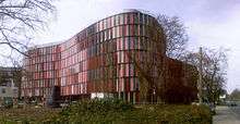
It combines the residential neighbourhoods from adjacent Marienburg with former industrial areas next to the old "Dom" brewery.[1][2] Bayenthal has 8.473 inhabitants (as of 31 December 2008) and covers an area of 1,28 km² (pop.density of 6.620 inhab./km²). The neighbourhood is served by Cologne Stadtbahn line 16.
References
- ↑ Housing and Commercial Development in Bayenthal, Cologne Archived March 22, 2009, at the Wayback Machine., DETAIL magazine (in English)
- ↑ Bayenthal: Cologne for Insiders (in German)
External links
- official site (in German)
| Wikimedia Commons has media related to Köln-Bayenthal. |
Coordinates: 50°54′44″N 6°58′3″E / 50.91222°N 6.96750°E
| Authority control |
|---|