Battle of Wandiwash
| Battle of Wandiwash | |||||||
|---|---|---|---|---|---|---|---|
| Part of Seven Years' War | |||||||
 The Vandavasi fort. | |||||||
| |||||||
| Belligerents | |||||||
|
|
| ||||||
| Commanders and leaders | |||||||
| Sir Eyre Coote | Count de Lally | ||||||
| Strength | |||||||
| 80 European Horses, 250 Native horses, 1,900 European Infantry, 2,100 Sepoys and 26 pieces of Artillery | 300 European Cavalry, 2,250 European Infantry, 1,300 Sepoys, 3,000 Mahrattas and 16 pieces of Artillery | ||||||
The Battle of Wandiwash was a decisive battle in India during the Seven Years' War. The Count de Lally's army, burdened by a lack of naval support and funds, attempted to regain the fort at Vandavasi, now in Tamil Nadu. He was attacked by Sir Eyre Coote's forces and decisively defeated. The French general Marquis de Bussy-Castelnau and the French were then restricted to Pondichéry, where they surrendered on 16 January 1761. Wandiwash is the Anglicised pronunciation of Vandavasi.[1]
This was the Third Carnatic War fought between the French and the British. Having made substantial gains in Bengal and Hyderabad, the British, after collecting huge amount of revenue, were fully equipped to face the French in Wandiwash, whom they defeated.
According to the 19th century book Annals of the Wars of the Eighteenth Century by Author Eduard Cust, the French Army consisted of 300 European Cavalry, 2,250 European infantry, 1,300 sepoys (soldiers), 3,000 Mahrattas and 16 pieces of artillery while the English deployed about 80 European Horses, 250 Native horses, 1,900 European Infantry, 2,100 sepoys and 26 pieces of artillery.[2] The Battle of Wandiwash involved capture of Chetpattu (Chetpet), Tirunomalai (Thiruvannaamalai), Tindivanam and Perumukkal.[3]
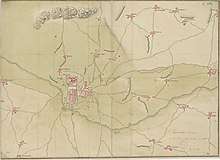
Map

See also
References
- ↑ Heritage History – List of Battles Archived 11 July 2011 at the Wayback Machine., retrieved 30 September 2008
- ↑ Eduard Cust (1862). Annals of the wars of the eighteenth century, compiled from the most authentic histories of the period , Volume 3.
- ↑ John Henry Garstin, Lawrence Asylum Press (1878). Manual of the South Arcot district.
External links
Coordinates: 12°30′00″N 79°37′12″E / 12.5000°N 79.6200°E
.