Bathgate (Lower) railway station
| Bathgate (Lower) | |
|---|---|
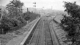 Bathgate (Lower) railway station in 1962 | |
| Location | |
| Place | Bathgate |
| Area | West Lothian |
| Coordinates | 55°54′16″N 3°38′59″W / 55.904333°N 3.649714°WCoordinates: 55°54′16″N 3°38′59″W / 55.904333°N 3.649714°W |
| Grid reference | NS969691 |
| Operations | |
| Original company | Monkland Railways |
| Pre-grouping | North British Railway |
| Post-grouping | LNER |
| Platforms | 2 |
| History | |
| 1856 | Opened as Bathgate[1] |
| 1 August 1865 | Renamed as Bathgate Lower[1] |
| 1 May 1930 | Closed[1] |
| Disused railway stations in the United Kingdom | |
|
Closed railway stations in Britain A B C D–F G H–J K–L M–O P–R S T–V W–Z | |
|
| |
Bathgate (Lower) railway station was a railway station serving the town of Bathgate in West Lothian, Scotland. It was located on the Bathgate Branch of the Monkland Railways.
History
Bathgate was opened by the Monkland Railways in 1856,[1] and renamed Bathgate Lower on 1 August 1865[1] by the North British Railway at the same time as the Edinburgh and Bathgate Railway station of the same name was renamed Bathgate Upper.[1]
The station was closed, along with the other station on the branch - Westfield - by the LNER on 1 May 1930.
Bathgate (Lower) was situated between Easton Road and Cochrane Street in Bathgate. From the station, a branch continued to Balbardie Colliery to the north east of the station, and a further branch to Easton Colliery to the south west of the station. The main branch continued 4 miles and 6 chains west from Bathgate (Lower) to Blackston Jct, where it joined the Slamannan Railway
Services
| Preceding station | Disused railways | Following station | ||
|---|---|---|---|---|
| Westfield Line and station closed |
North British Railway Bathgate Branch of Monkland Railways |
Bathgate (Upper) Line and station closed | ||
References
Notes
Sources
- Butt, R. V. J. (1995). The Directory of Railway Stations: details every public and private passenger station, halt, platform and stopping place, past and present (1st ed.). Sparkford: Patrick Stephens Ltd. ISBN 978-1-85260-508-7. OCLC 60251199.
- Jowett, Alan (March 1989). Jowett's Railway Atlas of Great Britain and Ireland: From Pre-Grouping to the Present Day (1st ed.). Sparkford: Patrick Stephens Ltd. ISBN 978-1-85260-086-0. OCLC 22311137.
- Jowett, Alan (2000). Jowett's Nationalised Railway Atlas (1st ed.). Penryn, Cornwall: Atlantic Transport Publishers. ISBN 978-0-906899-99-1. OCLC 228266687.
- RAILSCOT on Bathgate Branch of Monkland Railways