Barum, Lüneburg
| Barum | ||
|---|---|---|
| ||
 Barum Location of Barum within Lüneburg district 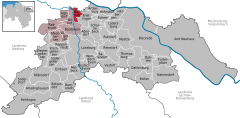  | ||
| Coordinates: 53°21′7″N 10°24′22″E / 53.35194°N 10.40611°ECoordinates: 53°21′7″N 10°24′22″E / 53.35194°N 10.40611°E | ||
| Country | Germany | |
| State | Lower Saxony | |
| District | Lüneburg | |
| Municipal assoc. | Bardowick | |
| Government | ||
| • Mayor | Werner Meyn (CDU) | |
| Area | ||
| • Total | 9.8 km2 (3.8 sq mi) | |
| Elevation | 4 m (13 ft) | |
| Population (2017-12-31)[1] | ||
| • Total | 2,013 | |
| • Density | 210/km2 (530/sq mi) | |
| Time zone | CET/CEST (UTC+1/+2) | |
| Postal codes | 21357 | |
| Dialling codes | 04133 | |
| Vehicle registration | LG | |
| Website | Homepage der Samtgemeinde | |

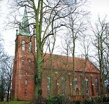
St. Dionysius-Church in St. Dionys
Barum is a municipality in the district of Lüneburg, in Lower Saxony, Germany. Barum has an area of 9.8 km² and a population of 1,844 (as of December 31, 2007). Barum is subdivided into the parts Barum, Horburg and St. Dionys. Barum is crossed by the river Neetze.
References
| Authority control |
|---|
This article is issued from
Wikipedia.
The text is licensed under Creative Commons - Attribution - Sharealike.
Additional terms may apply for the media files.