Bartolomé Masó, Cuba
| Bartolomé Masó | |
|---|---|
| Municipality | |
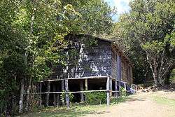 View of the Comandancia General de La Plata | |
.png) Bartolomé Masó municipality (red) within Granma Province (yellow) and Cuba | |
 Location of Bartolomé Masó in Cuba | |
| Coordinates: 20°10′7″N 76°56′34″W / 20.16861°N 76.94278°WCoordinates: 20°10′7″N 76°56′34″W / 20.16861°N 76.94278°W | |
| Country |
|
| Province | Granma |
| Area[1] | |
| • Total | 629 km2 (243 sq mi) |
| Elevation | 65 m (213 ft) |
| Population (2004)[2] | |
| • Total | 53,024 |
| • Density | 84.3/km2 (218/sq mi) |
| Time zone | UTC-5 (EST) |
| Area code(s) | +53-23 |
Bartolomé Masó (Spanish pronunciation: [baɾtoloˈme maˈso]) is a municipality and town in the Granma Province of Cuba.
Overview
The municipality was named after the Cuban patriot Bartolomé Masó Márquez. It is the home of the Comandancia General de La Plata, headquarters of the Cuban revolutionaries around Fidel Castro and today a museum, located in the Sierra Maestra mountains.[3]
Demographics
In 2004, the municipality of Bartolomé Masó had a population of 53,024.[2] With a total area of 629 km2 (243 sq mi),[1] it has a population density of 84.3/km2 (218/sq mi).
See also
References
- 1 2 Statoids (July 2003). "Municipios of Cuba". Archived from the original on 12 October 2007. Retrieved 2007-10-06.
- 1 2 Atenas.cu (2004). "2004 Population trends, by Province and Municipality" (in Spanish). Archived from the original on 2006-07-14. Retrieved 2007-10-06.
- ↑ (in Spanish) Comandancia General de La Plata on EcuRed
External links
![]()
This article is issued from
Wikipedia.
The text is licensed under Creative Commons - Attribution - Sharealike.
Additional terms may apply for the media files.