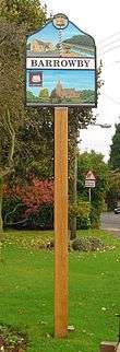
Barrowby
| Barrowby | |
|---|---|
 Barrowby Barrowby shown within Lincolnshire | |
| OS grid reference | SK880363 |
| • London | 100 mi (160 km) S |
| District | |
| Shire county | |
| Region | |
| Country | England |
| Sovereign state | United Kingdom |
| Post town | GRANTHAM |
| Postcode district | NG32 |
| Dialling code | 01476 |
| Police | Lincolnshire |
| Fire | Lincolnshire |
| Ambulance | East Midlands |
| EU Parliament | East Midlands |
| UK Parliament | |
Barrowby is a village and civil parish in the South Kesteven district of Lincolnshire, England. It lies 2 miles (3.2 km) west of Grantham town centre in a position overlooking the Vale of Belvoir. It has a Grade I listed parish church. The 2001 Census listed 795 households and a population of 1,996,[1] which fell to 1,952 in 840 households at the 2011 census.[2] This may reflect a fall in the size of households.
History
The first written records for Barrowby are in the Domesday Book of 1086, in which the village is referred to as "Bergebi", thought to derive from Scandinavian languages 'berg-by' meaning 'village by the hill'. The Domesday record shows that there was a church with a priest and 60 acres (0.24 km2) of meadow. The village belonged until the 19th century to the historical wapentake of Winnibriggs and Threo.[3]
The Domesday village of Casthorpe is 1.5 miles (2.4 km) west from Barrowby. By the 14th century it was referred to in records as two holdings, East[4] and West[5] Casthorpe. It is now little more than a cluster of farm buildings.[6] A further deserted medieval village is Newbo, 1.5 miles (2.4 km) to the north-west, which was located by archaeologists in 1970.[7]
Geography
Barrowby is situated where the A52 road crosses the A1 road which separates the village from the western edge of Grantham. The village is close to the Lincolnshire border with Leicestershire and Nottinghamshire.
Barrowby is 300 feet (91 m) above sea level, and adjacent to the Vale of Belvoir. From the village can be seen Belvoir Castle, Lincoln Cathedral, and power stations in the Trent valley, including West Burton and Cottam, near Gainsborough over 40 miles (60 km) away.
Adjoining villages include Sedgebrook, Harlaxton, Denton and the hamlets of Casthorpe and Stenwith.
Culture and community
There has been a Barrowby fête or gala in various forms since the 1950s. From 2004 until recently, an annual Barrowby Gala and Beer Festival was held on the village green. The event, with stalls, games, fairground rides, and tug of war, was organised by a committee of village residents.
Barrowby combines old buildings, cottages and manor houses, with newer buildings in a housing estate built within the last few decades. Linking the new housing estate and the original Barrowby centre are two main roads, High Road and Low Road. Some surrounding road names reflect the names of patrons and residents who established and shaped the village.[8]
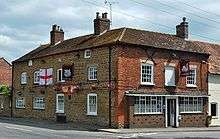
Barrowby contains a post office, a cafe, a butcher's and a British Legion Club. The village public house is The White Swan. Until 1959 there was a second public house, The Marquis of Granby Inn,[9] situated at the corner of Welby Court and Main Street. It is pictured in a 1910 postcard of the village.
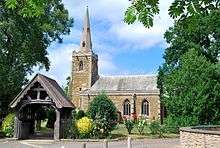
The Anglican Grade I listed parish church, dedicated to All Saints, was built between the 13th and 14th centuries from ironstone and limestone, in the Early English and Perpendicular Gothic styles. The church was extensively restored in 1852 and 1870.[10] It includes a medieval door on the south side of the chancel, a humorous corbel at the foot of a south window, depicting a head that seems to have been pinched out of place by the adjacent buttress, and a blocked north door. Significant internal features include stained glass windows.[11]
The ecclesiastical parish belongs to the Barrowby and Great Gonerby group in the Deanery of Grantham, Diocese of Lincoln. The incumbent is Rev Peter Hopkin.s[12] Services are held in Gonerby and at All Saints.[13]
Education
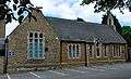
Barrowby parish school was built in 1852 adjacent to the church. Part of the original school hall and bell tower remain. It has since been modernised with additional new buildings. The school has an Ofsted rating of "outstanding";[14] from September 2010 to April 2011, 6% of schools were judged as outstanding by Ofsted. It has a school roll of approximately 240 pupils from 4–11 years and has received Basic Skills Mark, Healthy Schools, and Eco-Schools Silver Status awards.[15][16]
Notable people
- Dr Thomas Hurst was born in the village in 1598 and became rector of Barrowby in 1629. He was chaplain to King Charles I.[17]
- Sir John Thorold, 4th Baronet was a landowner who owned about one quarter of the parish, the other parts split between the Duke of Devonshire and the Welby family. The Thorold family also owned land in nearby villages of Casthorpe and Sedgebrook. Thorold Road is named after Sir John Thorold.
Further reading
- De Ville, Eileen: Guide to Barrowby Parish Church, All Saints (1977), Journal Commercial Printers, 1977
- Barrowby : a guide to the archaeology of the Parish, King's School, Archaeological Society c. 1971
 Barrowby old schoolhouse
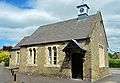 Barrowby reading room
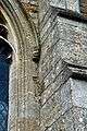 Corbel on All Saints, pushed out by buttress
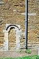 Barrowby All Saints blocked south chancel door
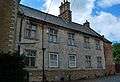 17th-century house in Barrowby
References
- ↑ "Neighbourhood statistics". 2001 census. Office for National Statistics. Retrieved 20 April 2013.
- ↑ "Civil parish population 2011". Neighbourhood Statistics. Office for National Statistics. Retrieved 22 April 2016.
- ↑ Vision of Britain site: Retrieved 16 March 2012.
- ↑ Historic England. "DMV at East Casthorpe (323653)". PastScape. Retrieved 10 April 2010.
- ↑ Historic England. "DMV at West Casthorpe (323656)". PastScape. Retrieved 10 April 2010.
- ↑ Lost Villages Retrieved 14 May 2018.
- ↑ Historic England. "DMV at Newbo (891671)". PastScape. Retrieved 10 April 2010.
- ↑ Street name list Retrieved 14 May 2018.
- ↑ "Lost pubs in Barrowby, Lincolnshire".
- ↑ Historic England. "Church (323676)". PastScape. Retrieved 10 April 2010.
- ↑ http://www.barrowbychurch.org.uk/
- ↑ "Ecclesiastical Parish details". Archived from the original on 16 July 2011.
- ↑ "All Saint's church web site".
- ↑ "Barrowby C of E Primary School: Ofsted Report 2011" (PDF). Ousted. Retrieved 22 February 2016.
- ↑ "Barrow by C of E School: Ofsted Dashboard". www.ofsted.gov.uk. Retrieved 22 February 2016.
- ↑ "Barrowby C of E Primary School". www.barrowby.lincs.sch.uk. Retrieved 22 February 2016.
- ↑ Grantham Civic Society report Retrieved 14 May 2018.
External links

- Location map of Barrowby
- Aerial view of Barrowby
- Web site of Barrowby CofE Primary School, Barrowby
- All Saints Church Barrowby
- Barrowby Improvement Group (B.I.G.)
- Barrowby in the Domesday Book
England Portal | |
| Unitary authorities | |
| Boroughs or districts | |
| Major settlements |
|
| Topics | |