Barberville Falls
| Barberville Falls | |
|---|---|
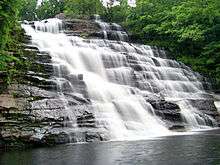 The falls in 2012 | |
| Location | The Hamlet of Barberville, in Poestenkill, Rensselaer County, New York[1] |
| Total height | 92 feet |
| Total width | 55 feet |
The Barberville Falls is a waterfall and nature preserve located in Poestenkill, New York. The fall flows into the Poesten Kill, which is a large creek that flows through Rensselaer County.
Features
Above Barberville, the Poesten Kill flows about 35 square miles on the Rensselaer Plateau — an area from Dyken Pond on the north to Taborton on the south. This drainage basin generates a substantial flow of water throughout the year, although the flow is most dramatic in the spring when the winter snow melts. When it reaches the Hudson River at Troy, this same flow of water provided hydraulic power for much of the city's early industrial development.
Below the falls, the stream flows through a large gore 100 feet deep and 500 to 1,000 feet wide. The waterfall itself is about 90 feet high and 50 feet wide. The main rock type at the falls is Rensselear Greywacke; above the falls are large beds of slate and limestone.[2]
Trails
The nature preserve has three main carved trails; The Creek Trail, The Falls Trail, and The Ridge Trail.
The Creek Trail is located just northwest of the parking area along Plank Road. It is a smooth, unmarked trail except for signs at it's ends. It goes down a slope to the banks of the Poestenkill and then continues a short distance both upstream and downstream. Round trip is approximately a mile.
The Falls Trail is .3 miles south of the parking area on Ives Corners Road (some maps show it as Blue Factory Road). The trailhead is well marked and the trail is relatively flat to the top of the falls. Stoneworks of a mill project that was never finished can be seen on the trail. The trail descends steeply from here to the bottom of the falls. Round trip is approximately a half mile.
The Ridge Trail is .1 miles along Ives Corner Road and may be difficult to locate. It is opposite the fourth telephone pole from the Falls Trail and a person may need to get up on the bank to see the trail sign. The trail is generally well defined and marked with orange diamonds or orange ribbon in a few spots. The trail starts out rocky as it winds its way around a flattened stone fence but quickly joins up with what was probably an old cart path used by the neighboring farm. Right before that intersection there is a junction for the loop the trail makes but it is not well marked from this side. At approximately .75 of a mile the trail makes a sharp left onto a less wide but still well defined path through the woods. One does have to cross four tributaries to the Poestenkill but they are narrow and stepping stones can be found to cross over dryly. The trail comes to the Poestenkill opposite the southern terminus of the Creek Trail and then climbs a ridge alongside of the stream. While glimpses of the falls can be seen from the trail, hemlocks block a clear view. Round trip is approximately 1.3 miles.[3]
References
- ↑ "Barberville Falls". www.google.com. Retrieved 2016-09-03.
- ↑ "Barberville Falls | The Nature Conservancy". www.nature.org. Retrieved 2016-09-11.
- ↑ "AMC Mohawk Hudson Chapter Outdoor Areas". www.amcmohawkhudson.org. Retrieved 2016-09-11.