Bannertown, North Carolina
| Bannertown | |
|---|---|
| Unincorporated community | |
 Bannertown Location within the state of North Carolina | |
| Coordinates: Coordinates: 36°29′10″N 80°35′24″W / 36.486°N 80.590°W | |
| Country | United States |
| State | North Carolina |
| County | Surry |
| Time zone | UTC-5 (Eastern (EST)) |
| • Summer (DST) | UTC-4 (EDT) |
| GNIS feature ID | 980532 |
Bannertown is an unincorporated community in Surry County, North Carolina just outside the city of Mount Airy (Powell 1968, p. 23). The community is centered on the intersection of Business U.S. Highway 52 (S. Main Street) and North Carolina Highway 89 (Westfield Road). Some of the area, specifically from the center of the community to the Ararat River has been annexed by Mount Airy in recent years.
References
Powell, William S. (1968), The North Carolina Gazetteer: A Dictionary of Tar Heel Places, Chapel Hill: University of North Carolina Press, ISBN 0-8078-1247-1
Municipalities and communities of Surry County, North Carolina, United States | ||
|---|---|---|
| City | 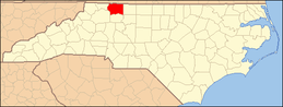 | |
| Towns | ||
| Townships | ||
| CDPs | ||
| Unincorporated communities |
| |
| Footnotes | ‡This populated place also has portions in an adjacent county or counties | |
This article is issued from
Wikipedia.
The text is licensed under Creative Commons - Attribution - Sharealike.
Additional terms may apply for the media files.