Bangli Regency
| Bangli Regency Kabupaten Bangliᬓᬩᬸᬧᬢᬾᬦ᭄ᬩᬂᬮᬶ | ||
|---|---|---|
| Regency | ||
| ||
| Motto(s): Bhukti Mukti Bhakti | ||
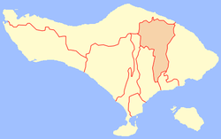 Location of Bangli Regency | ||
| Coordinates: 8°17′0″S 115°20′0″E / 8.28333°S 115.33333°ECoordinates: 8°17′0″S 115°20′0″E / 8.28333°S 115.33333°E | ||
| Country |
| |
| Province |
| |
| Capital | Bangli | |
| Government | ||
| • Regent | I Made Gianyar | |
| Area | ||
| • Total | 520.81 km2 (201.09 sq mi) | |
| Population (2010) | ||
| • Total | 213,808 | |
| • Density | 410/km2 (1,100/sq mi) | |
| Time zone | UTC+8 (WITA) | |
| Area code(s) | +62 366 | |
| Website | www.banglikab.go.id | |

Bangli is a regency (kabupaten) of Bali, Indonesia. It has an area of 520.81 km2 and population of 197,210 (2004). Its regency seat is Bangli.
Up till 1907, Bangli was one of the nine kingdoms of Bali. The capital has a famous Hindu temple, the Pura Kehen, which dates from the 11th century. Bangli also has one village, lies surround a hill, Demulih.
The northern part of the district included the main road to the north coast passing through Kintamani and around the crater in which Gunung Batur sits.[1]
From the Demulih hill, Bali Island, particularly its southern part can be seen – Kuta, Nusa Dua, Gianyar and a part of Klungkung.
Bangli is the only regency in Bali which landlocked.
Administration
The regency is divided into four districts (kecamatan):
- Susut
- Bangli
- Tembuku
- Kintamani
Notes
- ↑ p.435 of Dalton, Bill 1988 Indonesia Handbook 4th edition
External links
![]()
| Wikimedia Commons has media related to Bangli Regency. |
| Subdistricts |
| |
|---|---|---|