Banggai Island
 | |
| Geography | |
|---|---|
| Location | South East Asia |
| Coordinates | 1°37′S 123°34′E / 1.617°S 123.567°E |
| Archipelago | Banggai Islands |
| Area | 268 km2 (103 sq mi) |
| Administration | |
|
Indonesia | |
| Province | Central Sulawesi |
| Demographics | |
| Population | 37,155 (2010 Census) |
| Pop. density | 138.6 /km2 (359 /sq mi) |
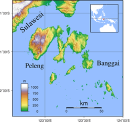
Banggai Island is the second largest of the Banggai Islands, an archipelago located at the far eastern end of Central Sulawesi, Indonesia. The largest island is Peleng, smaller islands of the group are Bowokan, Labobo, Kebongan, Kotudan, Tropettenando, Timpau, Salue Besar, Salue Kecil, Masepe, and Bangkulu.
Banggai Island has an area of 268 square kilometres (103 sq mi) and a population of 37,155 (2010 census).
References
This article is issued from
Wikipedia.
The text is licensed under Creative Commons - Attribution - Sharealike.
Additional terms may apply for the media files.