Bang Yi Ruea
Bang Yi Ruea (Thai: บางยี่เรือ) is an one khwaeng (แขวง; sub-district) in Thon Buri district, Thonburi side of Bangkok. It has a total area of 1.523 km2 (round about 0.588 mi2).[1]
Originally, this area was called "Bang Sakae" (บางสะแก), that refers to "hamlet of combretum", because it's an area adjacent to the canal. Combretums are densely populated that can be used as a hiding place as well. It's surrounded by three waterways viz Khlong Bang Luang (คลองบางหลวง; Bang Luang canal–better known as Khlong Bangkok Yai), Khlong Bang Nam Chon (คลองบางน้ำชน; Bang Nam Chon canal), Khlong Tha Phra (คลองท่าพระ; Tha Phra canal). In the Thonburi period corresponds to the days of King Taksin. This area was used as a hiding place for firing to the Burmese army's boats. So it was called "Bunk Ying Ruea" (บังยิงเรือ) literally means "hiding to fire a boat", and wrong pronunciation to "Bang Yi Ruea" finally. Including as the home of the Mon who escaped war from Burma.[2][3]
Later on, in the Ratanakosin period. Bang Yi Ruea is an amphoe (อำเภอ; district) under the administration of Thonburi province named "Amphoe Rajkrueh" (อำเภอราชคฤห์) and changed its name to Bang Yi Ruea in 1916. Later on, in 1939, amphoe Bang Yi Ruea was renamed to Amphoe Thon Buri to commemorate King Taksin, and it has been modified several times until the sub-district status as today.[4]
Places
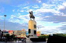
- Wongwian Yai & King Taskin Memorial
- Thon Buri District Office
- Talat Phlu
- Bang Yi Ruea Junction
- Bang Yi Reua Metropolitan Police Station
- Naowa Chamnian Bridge–the beginning of Petchkasem road, the longest road in Thailand
- Wat Welurachin
- Wat Rajkrueh (Wat Bang Yi Ruea Nai, Wat Bang Yi Ruea Nuea)
- Wat Chantharam (Wat Klang Talat Phlu)
- Wat Intharam (Wat Tai, Wat Bang Yi Ruea Tai)
- Masjid Suan Phlu
References
- ↑ กองนโยบายและแผนงาน. สำนักผังเมือง. กรุงเทพมหานคร. "ประชากรกรุงเทพมหานครและปริมณฑล พ.ศ. 2549." (PDF). BMA (in Thai).
- ↑ สุขแย้ม, ชวนพิศ (2006-09-12). "บังยิงเรือ.....ที่ตลาดพลู...???". Gotoknow (in Thai).
- ↑ บาราย (2009-12-06). "วัดบังยิงเรือเหนือ". Thairath (in Thai).
- ↑ "ประวัติและข้อมูลทั่วไปของเขตธนบุรี". Thon Buri District Office (in Thai).
Coordinates: 13°43′38.21″N 100°29′13.39″E / 13.7272806°N 100.4870528°E