Bang Khen District
| Bang Khen บางเขน | |
|---|---|
| Khet | |
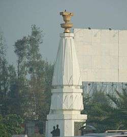 Anusawari Bangkhen, aka Constitutional Protection Monument | |
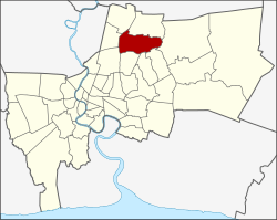 Khet location in Bangkok | |
| Coordinates: 13°52′26″N 100°35′47″E / 13.87389°N 100.59639°ECoordinates: 13°52′26″N 100°35′47″E / 13.87389°N 100.59639°E | |
| Country | Thailand |
| Province | Bangkok |
| Seat | Anusawari |
| Khwaeng | 2 |
| Area | |
| • Total | 42.123 km2 (16.264 sq mi) |
| Population (2017) | |
| • Total | 190,681[1] |
| • Density | 4,526.76/km2 (11,724.3/sq mi) |
| Time zone | UTC+7 (ICT) |
| Postal code |
10220 except Mu 8-10 of Tha Raeng: 10230 |
| Geocode | 1005 |
Bang Khen (Thai: บางเขน, pronounced [bāːŋ kʰěːn]) is one of the 50 districts (khet) of Bangkok, Thailand. It is bounded by other Bangkok districts (from north clockwise): Sai Mai, Khlong Sam Wa, Khan Na Yao, Bueng Kum, Lat Phrao, Chatuchak, Lak Si, and Don Mueang.
History
Bang Khen was established as an amphoe (district) of Phra Nakhon Province in 1897. The district occupied a vast plain called Thung Bang Khen (ทุ่งบางเขน; 'Bang Khen Field') in north Bangkok. Farms dominated its landscape.[2] In October 1933, the district was a battleground in the "Boworadet rebellion" contested by the army of Prince Boworadet and government troops.[3]
In 1972, Thonburi and Phra Nakhon Provinces were combined and called Krung Thep Maha Nakhon. Administrative units within the capital were renamed "districts" (khet) and "sub-district" (khwaeng), replacing "amphoe" and "tambon" respectively. Bang Khen became a district in the newly combined province. At that time it had eight sub-districts.
Bang Khen was once a very large district, but has been reduced in size after several modifications to district boundaries. In 1989, western and southwestern portions were split off to create Don Mueang District and Chatuchak District respectively. In 1997, a northern portion of Bang Khen was split off to create Sai Mai District, but in the same reorganization Bang Khen received Moo 8-10 of Chorakhe Bua Sub-district from Lat Phrao District.
As of 2018 the Thai Army's 11th Infantry Division occupies 3,000 rai of land in Bang Khen.[4]
Places of interest
- Wat Phra Si Mahathat Wora Maha Wiharn (วัดพระศรีมหาธาตุวรมหาวิหาร) Temple of Holy Relics
- Constitutional Protection Monument (อนุสาวรีย์พิทักษ์รัฐธรรมนูญ) at Lak Si Circle (วงเวียนหลักสี่)
- Sathira Dhammasathan (เสถียรธรรมสถาน) Buddhist Retreat Center
- Ying Charoen Market (ตลาดยิ่งเจริญ) or Saphan Mai Market (ตลาดสะพานใหม่). The original name of Saphan Mai was Saphan Sukoranakhaseni (สะพานสุกรนาคเสนีย์)
- Lumphini Boxing Stadium (สนามมวยเวทีลุมพินี) Muay Thai arena moved from Pathum Wan in 2014
Education
- Phranakhon Rajabhat University, (Khwaeng Anusawari)
- Rattanakosin Somphot Bangkhen School, (Khwaeng Tha Raeng)
- Bangkhen District non-formal and informal Education, (Khwaeng Anusawari)
- Krirk University
Governance
The district is divided into two sub-districts (khwaeng): Anusawari (อนุสาวรีย์) and Tha Raeng (ท่าแร้ง).
District council
The Bang Khen district council has eight members, who serve four-year terms. Elections were last held on 30 April 2006. The Thai Rak Thai Party won all eight seats.
References
- ↑ "Population and House Report for Year 2017". Department of Provincial Administration, Ministry of Internal Affairs. Retrieved 2018-04-01. (Search page)
- ↑ "ยุคสมัยผ่านไปไวกว่าที่คิด-ชวนชมภาพเก่าเล่าเรื่องราวของกรุงเทพในอดีต". Khao Sod (in Thai). 2015-08-15.
- ↑ "เคยเกิดอะไรในทุ่งบางเขน". Posttoday (in Thai). 2014-04-13.
- ↑ "Thai Liberal Party vows to reform Thai Army". Pratchatai English. 2018-04-05. Retrieved 13 September 2018.
External links
- BMA website with the tourist landmarks of Bang Khen
- Bang Khen district office (Thai only)
- Map of Bang Khen District
.svg.png)