Bamrung Mueang Road
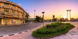
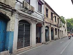
Bamrung Mueang Road (Thai: ถนนบำรุงเมือง, pronounced [tʰā.nǒn bām.rūŋ mɯ̄a̯ŋ]) is the second paved road in Bangkok. It was built in 1863 after Charoen Krung Road, in the reign of King Mongkut (Rama IV). It cut through the old fortified city of Rattanakosin Island from west to east, beginning near the Grand Palace, passing the Giant Swing and running eastward to Khlong Phadung Krung Kasem. It continues on as Rama I Road after crossing Kasat Suek Bridge. It was the main thoroughfare as the city expanded eastward and away from the Chao Phraya river in the early 20th century.[1][2]
This road is unique in that it has no footpath at the beginning phase (around Giant Swing and Pratu Phi) like other roads. And it has been like this since the first built completed.[3]
References
- ↑ Naenna, Oranee (2002). นามนี้มีที่มา [These names have origins] (in Thai). Bangkok: Praphansan. pp. 45–46. ISBN 9789742308483.
- ↑ Wilson, Constance M. (July 1989). "Bangkok in 1833: An Economic and Social Profile" (PDF). Journal of the Siam Society. 77 (2): 49–58. Retrieved 19 January 2017.
- ↑ "สามแพร่ง...ทางแยกแห่งทวิภพ". Pinijnakorn (in Thai). 2009-02-23.
| Wikimedia Commons has media related to Bamrung Mueang Road. |
Coordinates: 13°45′07″N 100°30′30″E / 13.75194°N 100.50833°E