Ballyferriter
| Ballyferriter Baile an Fheirtéaraigh | |
|---|---|
| Village | |
 Ballyferriter, County Kerry, Ireland | |
 Ballyferriter Location in Ireland | |
| Coordinates: 52°10′31″N 10°24′50″W / 52.175195°N 10.414009°WCoordinates: 52°10′31″N 10°24′50″W / 52.175195°N 10.414009°W | |
| Country | Ireland |
| Province | Munster |
| County | County Kerry |
| Irish Grid Reference | Q352044 |
| Official name: Baile an Fheirtéaraigh. | |
Ballyferriter (Irish: Baile an Fheirtéaraigh, meaning "Ferriter's townland", Irish pronunciation: [ˈbˠalʲənʲ ɛɾˠˈtʲeːɾˠiɡʲ] or An B[h]uailtín),[1]), is a Gaeltacht village in County Kerry, Ireland. It is in the west of the Corca Dhuibhne (Dingle) peninsula and according to the 2002 census, about 75% of the town's population speak the Irish language on a daily basis. The village is named after the Norman-Irish Feiritéar family who settled in Ard na Caithne in the late medieval period and of whom the seventeenth-century poet and executed leader, Piaras Feiritéar, was a member. The older Irish name for the village An B[h]uailtín ("the little dairy place") is still used locally.
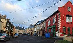
The village lies at the base of Croaghmarhin hill near Cuan Ard na Caithne (formerly also called Smerwick harbour) on the Dingle peninsula, on the R559 regional road which loops around the west of the peninsula, beginning and ending in Dingle Town. It has three pubs and one hotel. It also has a school, church, museum, Músaem Chorca Dhuibhne,[2] the offices of the local co-op, Comharchumann Forbartha Chorca Dhuibhne, and a Garda station.
The village is busier due to an influx of Irish students throughout the summer, when both youngsters and adults attend Irish language courses in the local national school and other venues in the village. University College Cork also owns a house there that facilitates year-long study for students at a higher level.
Between Ballyferriter and Smerwick Harbour is Dún an Óir (the Fort of Gold), an Iron Age promontory fort, which was the location of the Siege of Smerwick, a massacre in 1580. A 600-strong Spanish and Italian papal invasion force which had come as part of the Second Desmond Rebellion of James Fitzmaurice Fitzgerald were besieged and massacred by the English crown forces of Arthur Grey, 14th Baron Grey de Wilton.
Under a placenames order in 2004, the Minister for the Gaeltacht, Éamon Ó Cuív declared that on maps and signage the Irish name, Baile an Fheirtéaraigh, must be used.[3]
References
- ↑ Placenames Database of Ireland
- ↑ http://www.westkerrymuseum.com/ Dingle Peninsula Museum website
- ↑ "An tOrdú Logainmneacha (Ceantair Ghaeltachta) 2004" (PDF). Government of Ireland.
