Ballochmyle Viaduct
| Ballochmyle Viaduct | |
|---|---|
 | |
| Coordinates | 55°29′29″N 4°23′57″W / 55.4914308°N 4.3990452°WCoordinates: 55°29′29″N 4°23′57″W / 55.4914308°N 4.3990452°W |
| Crosses | River Ayr |
| Characteristics | |
| Material | Stone |
| Height | 164 feet (50 m) |
| Longest span | 181 feet (55 m) |
| No. of spans | 7 |
| History | |
| Construction start | March 1846 |
| Construction end | 2 March 1848 |
| Opened | 9 August 1850 |

The Ballochmyle Viaduct is the highest extant railway viaduct in Britain. It is 169 feet (52 m) high, and carries the railway over the River Ayr in East Ayrshire, Scotland, close to the towns of Mauchline and Catrine. It carries the former Glasgow and South Western Railway line, running between the Scottish city of Glasgow via Kilmarnock and Dumfries to the border city of Carlisle.[1]
Designed by the noted engineering John Miller, the Ballochmyle Viaduct was built during the 1840s for the Glasgow, Paisley, Kilmarnock and Ayr Railway Company. Work commenced on its construction during March 1846; it was built under contract by Ross & Mitchell while William McCandlish served as the resident engineer. It is largely composed of red sandstone which was locally quarried, stronger stonework sources from Dundee was used for the structure’s arch rings however. Upon its completion on 2 March 1848, the Ballochmyle Viaduct featured the largest masonry arch anywhere in the world; even in the present day, this arch remains amongst the biggest to have ever been constructed.
The Ballochmyle Viaduct was first recognised as a listed structure during April 1971; it later became a Category A listed structure in January 1989. It was also designated as a ‘’National Historic Civil Engineering Landmark’’ by the Institution of Civil Engineers (ICE) during 2014. During the 2010s, national rail infrastructure company Network Rail undertook strengthening work upon the structure to help it cope with the rigors of the heavy freight traffic which was then using the route. The Ballochmyle Viaduct continues to be regularly used for both passenger and freight traffic through to the present day.
History
The Ballochmyle Viaduct was designed by the noted civil engineer John Miller of Edinburgh on behalf of the Glasgow, Paisley, Kilmarnock and Ayr Railway Company during the mid 1840s.[2][3] This line would later form the northern part of the railway from Glasgow to Carlisle via Kilmarnock. The construction of such a structure was necessitated by the presence of the River Ayr, over which a crossing was required to complete the envisioned route. The resident engineer that oversaw the viaduct’s construction was William McCandlish and the appointed contractors for its construction were Ross & Mitchell.[3][1][4]
During March 1846, construction activity upon the viaduct, which was largely composed of stone, commenced.[1] The work posed some challenges as the structure was incorporated a massive arch spanning directly over the River Ayr; in order to build this arch, complex timber centring, which was used as temporary supporting works, were constructed over and above the river. This centring was considered to be a noteworthy undertaking, if not remarkable accomplishment, in its own right.[5][6]
While the last stone of the structure placed on 2 March 1848, the railway itself was not completed until 9 August 1850.[1][7] At the time of its construction, the Ballochmyle Viaduct featured the largest masonry arch in the world; 150 years later, it still remained amongst the biggest masonry arches to have ever been built.[1] Since completion, the viaduct has carried a double track railway across the river approximately between the towns of Mauchline and Catrine;[8] as of 2015, it is believed that tens of thousands of trains have traversed the structure over the course of its lifetime.[9]
The Ballochmyle Viaduct has been in continuous use by railway traffic through to the present day; during 2014, it was observed that the structure was still in a good condition in spite of over 160 years of service.[10] However, it has not been without alteration during its life time. During the early 2010s, national rail infrastructure company Network Rail managed an upgrade programme upon the structure for the purpose of strengthening it to cope with heavy freight trains, particularly the coal traffic which regularly used the route; this work, which was performed by construction contractor Carillion, was deliberately performed without resulting in any significant alteration to the viaduct’s external appearance.[1][11][12]
The Ballochmyle Viaduct was first recognised as a listed structure during April 1971; it later became a Category A listed structure in January 1989.[13][1] It features in the 1996 film Mission: Impossible.[14][15] During 2014, the viaduct was designated as a ‘’National Historic Civil Engineering Landmark’’ by the Institution of Civil Engineers (ICE); a plaque marking this recognition has been installed upon the structure as well.[10][16] The viaduct is also listed amongst those sites promoted by the East Ayrshire Council as being a local historical site.[17]
Design
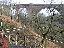
The Ballochmyle Viaduct carries a double-track railway over the River Ayr. In terms of its basic configuration, the structure is composed of seven spans, these being three 50 feet (15 m) spans set at either side of a central 181 feet (55 m) span.[3] This larger main arch crosses directly over the River Ayr at a height of 164 feet (50 m) at its highest point; as of the present day, this arch remains one of the largest masonry arches to have ever been constructed.[3] All of these arches are semi-circular, being built around an arch ring comprising hard stone quarried from a site outside the city of Dundee, which was brought to the construction area via the railway, while local red sandstone was used for the rest of the structure.[3] While largely plain, the arches do feature some decorative ornamentation; this includes a series of raised panels set upon the spandrels, as well as the dressed stone arch rings.[1] Reportedly, one of the best means of viewing these details is to approach the viaduct on foot via a riverside path that passes the structure directly underneath the large central arch.[18][19]
See also
References
- 1 2 3 4 5 6 7 8 "Ballochmyle Viaduct". engineering-timelines.com. Retrieved 4 January 2014.
- ↑ " Single record details: 234 - RHP99399." National Records of Scotland, Retrieved: 27 June 2018.
- 1 2 3 4 5 "Ballochmyle Viaduct". canmore.rcahms.gov.uk. Retrieved 4 January 2014.
- ↑ McCandlish, William. "Description of the Ballochmyle Viaduct over the River Ayr, on the line of the Glasgow and South-Western Railway." Journal of the Franklin Institute, Vol 50, Iss 6, December 1850. Pages 365-366.
- ↑ Cross-Rudlin, Peter. "Centres for Large Span Masonry Arch Bridges in Britain to 1833." arct.cam.ac.uk, pp. 887-901.
- ↑ Newlands, James. "Centering for the Ballochmyle Viaduct, Glasgow & South Western Railway, The Carpenter & Joiner's Assistant." Blackie & Son, Glasgow, 1860.
- ↑ Smith, Martin (1994). British Railway Bridges & Viaducts. ISBN 0-7110-2273-9.
- ↑ Google (23 January 2015). "Ballochmyle Viaduct" (Map). Google Maps. Google. Retrieved 23 January 2015.
- ↑ McKie, Rob. "The Railways: Nation, Network and People by Simon Bradley review – first-class." The Guardian, 18 October 2015.
- 1 2 "'Masterpiece' Ballochmyle Viaduct gets major award". The Scotsman. 25 April 2014. Retrieved 4 January 2014.
- ↑ “Ballochmyle Viaduct Structural Strengthening.” ‘’geo-structural.co.uk’’, Retrieved: 27 June 2018.
- ↑ core from the Ballochmyle Viaduct&used=The core was taken to establish the condition of the stone.&donor=April 2014&photo=2014_004_1.jpg&pane=3 "Museum Item : Sandstone." ICE Museum, Retrieved: 28 June 2018.
- ↑ "Ballochmyle Railway Viaduct: LB14483." portal.historicenvironment.scot, Retrieved: 27 June 2018.
- ↑ Simpson, Julie. “Ayrshire Gem – Mission Impossible.” ‘’dailyrecord.co.uk’’, 1 April 2011.
- ↑ "Ballochmyle Viaduct to become 'national historical civil engineering landmark'". Institution of Civil Engineers. Retrieved 23 January 2015.
- ↑ "Ballochmyle plaque unveiled." nrha.org.uk, July 2014.
- ↑ “Historic sites.” ‘’east-ayrshire.gov.uk’’, Retrieved: 27 June 2018.
- ↑ "Best Foot Forwards." heraldscotland.com, 30 October 1999.
- ↑ "River Ayr Way part 2." ramblers.org.uk, Retrieved: 27 June 2018.
External links
| Wikimedia Commons has media related to Ballochmyle Viaduct. |