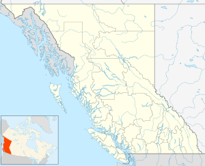
Balfour, British Columbia
| Balfour | |
|---|---|
| unincorporated community | |
 Balfour Location of Balfour in British Columbia, Canada | |
| Coordinates: 49°38′N 116°58′W / 49.633°N 116.967°WCoordinates: 49°38′N 116°58′W / 49.633°N 116.967°W | |
| Country |
|
| Province | British Columbia |
| Region | West Kootenay |
| Regional District | Central Kootenay |
| Government | |
| • Governing body | Nelson City Council |
| • MP | Alex Atamanenko (NDP) |
| • MLA | Corky Evans (NDP) |
| Area | |
| • Land | 3.72 km2 (1.44 sq mi) |
| Elevation | 571 m (1,873 ft) |
| Population (2016) | |
| • Total | 459 |
| • Density | 123.4/km2 (320/sq mi) |
| Time zone | UTC-8 (PST) |
| Area code(s) | 250 / 778 / 236 |
| Highways |
|
Balfour, also known as Balfour Bay, is an unincorporated community in British Columbia, located about 30 kilometres (19 mi) northeast of the city of Nelson and located at the juncture of Kootenay Lake with its West Arm.

It is the location of the Kootenay Lake Ferry, which is the longest toll-free vehicle ferry in North America. This marine link of the British Columbia highway system is made up of two vessels, the MV Osprey 2000, the larger of the two ferries with an 80 car capacity operating year round, and the MV Balfour, a 25 car ferry operating only in the summer.
Balfour was once the location of one of the Canadian Pacific's railway hotels, the Balfour Hotel,[1] which served the needs of passengers travelling the Southern Mainline of the CPR. Passengers and freight were carried across the lake by the CPR's Lake and River Service vessel, the SS Moyie, other vessels serving Kootenay Lake and also south up the Kootenai River to Bonner's Ferry, Idaho and up to Kaslo and other points northward on Kootenay Lake.
References
- ↑ Balfour Hotel (linked image is c.1918)
External links
- BC Archives Photo: Balfour Hotel,
- BC Archives Photo: Balfour Hotel, c.1915
- BC Archives Photo: Balfour Hotel, c.1918
- BC Archives Photo: CPR Steamer SS Moyie, near Balfour, c.1900 (hotel at rear left)