Balerno railway station
| Balerno | |
|---|---|
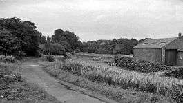 Balerno railway station in 1962 | |
| Location | |
| Place | Scotland |
| Area | Edinburgh |
| Grid reference | NT165670 |
| Operations | |
| Pre-grouping | Caledonian Railway |
| Post-grouping | London Midland and Scottish Railway |
| Platforms | 1 |
| History | |
| 1 August 1874 | Station opens [1] |
| 1 November 1943 | Station closes (LMS Last train)[1] |
| 1 June 1949 | Station closes (BR Officially)[1] |
| Disused railway stations in the United Kingdom | |
|
Closed railway stations in Britain A B C D–F G H–J K–L M–O P–R S T–V W–Z | |
|
| |
Balerno railway station served Balerno (now part of the city of Edinburgh). Services were provided by the Caledonian Railway using the Balerno Loop.
History
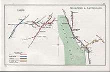
A 1914 diagram including Balerno
Opened by the Caledonian Railway, it became part of the London Midland and Scottish Railway during the Grouping of 1923, and that company ran the last train to use the station. However the line passed on the Scottish Region of British Railways on nationalisation in 1948 who officially closed the station in 1949.
| Preceding station | Historical railways | Following station | ||
|---|---|---|---|---|
| Ravelrig | Caledonian Railway Balerno Loop |
Currie | ||
The site today
The station master's house remains standing, in the site which has been landscaped as part of a garden.
References
Notes
Sources
- Butt, R. V. J. (1995). The Directory of Railway Stations: details every public and private passenger station, halt, platform and stopping place, past and present (1st ed.). Sparkford: Patrick Stephens Ltd. ISBN 978-1-85260-508-7. OCLC 60251199.
- Jowett, Alan (March 1989). Jowett's Railway Atlas of Great Britain and Ireland: From Pre-Grouping to the Present Day (1st ed.). Sparkford: Patrick Stephens Ltd. ISBN 978-1-85260-086-0. OCLC 22311137.
- Jowett, Alan (2000). Jowett's Nationalised Railway Atlas (1st ed.). Penryn, Cornwall: Atlantic Transport Publishers. ISBN 978-0-906899-99-1. OCLC 228266687.
- RAILSCOT on the Balerno Loop
- Balerno Station on navigable O. S. map
- Picture of the station
Coordinates: 55°53′22″N 3°20′16″W / 55.88958°N 3.33769°W
|    | ||||||||||||
|
| |||||||||||||
| |||||||||||||
| |||||||||||||
This article is issued from
Wikipedia.
The text is licensed under Creative Commons - Attribution - Sharealike.
Additional terms may apply for the media files.