Bald Mountain (Uinta Range)
| Bald Mountain | |
|---|---|
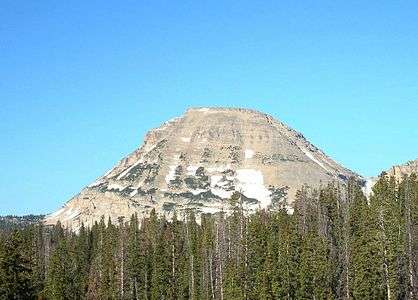 The east face of Bald Mountain. | |
| Highest point | |
| Elevation | 11,948 ft (3,642 m) NAVD 88[1] |
| Prominence | 1,823 ft (556 m) [1] |
| Coordinates | 40°41′56″N 110°54′09″W / 40.6988354°N 110.9023931°WCoordinates: 40°41′56″N 110°54′09″W / 40.6988354°N 110.9023931°W [2] |
| Geography | |
 Bald Mountain Location in Utah | |
| Location | Duchesne / Summit counties, Utah, U.S. |
| Parent range | Uinta Mountains |
| Topo map | USGS Mirror Lake |
| Climbing | |
| Easiest route | Hike |
Bald Mountain is a peak in the western Uinta Mountain Range in northeastern Utah, United States. It is an easy hike from Bald Mountain Pass, and has views of the surrounding areas. The mountain is home to mountain goats, pika, and a number of species of wildflowers.
The trail gains 1,250 feet (381 m) of elevation in 1.4 miles (2 km) and due to the high elevation (the trailhead is about 10,700 feet above sea level) it is a moderately strenuous hike with no shade. The hike to the summit can be completed in 2 to 3 hours round trip.
See also
References
- 1 2 "Bald Mountain, Utah". Peakbagger.com. Retrieved 2009-01-23.
- ↑ U.S. Geological Survey Geographic Names Information System: Bald Mountain
External links
![]()
- "Bald Mountain". SummitPost.org.
- Mirror Lake quadrangle, Utah (Map). 1:24000. 7.5 Minute Topographic. USGS.
- "Bald Mountain Uintas". UtahPictures.com. Archived from the original on 8 Feb 2009.
This article is issued from
Wikipedia.
The text is licensed under Creative Commons - Attribution - Sharealike.
Additional terms may apply for the media files.