Baitsi District
| Baitsi | |
|---|---|
| District | |
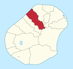 Baitsi District within Nauru | |
| Coordinates: 0°30′25″S 166°55′54″E / 0.50694°S 166.93167°ECoordinates: 0°30′25″S 166°55′54″E / 0.50694°S 166.93167°E | |
| Country |
|
| Constituency | Ubenide |
| Area | |
| • Total | 1.2 km2 (0.5 sq mi) |
| Elevation | 25 m (82 ft) |
| Population (2011) | |
| • Total | 513 |
| Time zone | (UTC+12) |
| Area code(s) | +674 |
Baitsi, formerly known as Baiti and previously as Beidi, is a district in the Pacific nation of Nauru. It belongs to Ubenide Constituency.
Geography
Location
The district is located in the northwest of the island. It covers an area of 1.2 km².
Former villages
| Former villages |
|---|
| Adrurior |
| Aeonun |
| Anakawida |
| Anut |
| Ataneu |
| Atirabu |
| Baiti (village) |
| Deradae |
| Ibedwe |
| Imangengen |
| Imaraga |
| Mangadab |
| Mereren |
| Umaruru |
| Yatabang |
See also
References
External links
![]()
This article is issued from
Wikipedia.
The text is licensed under Creative Commons - Attribution - Sharealike.
Additional terms may apply for the media files.