Anibare District
| Anibare | |
|---|---|
| District | |
.jpg) Anibare Harbour | |
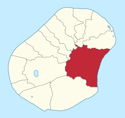 Anibare District within Nauru | |
| Coordinates: 0°31′50″S 166°56′40″E / 0.53056°S 166.94444°ECoordinates: 0°31′50″S 166°56′40″E / 0.53056°S 166.94444°E | |
| Country |
|
| Constituency | Anabar |
| Area | |
| • Total | 3.1 km2 (1.2 sq mi) |
| Elevation | 30 m (100 ft) |
| Population (2011) | |
| • Total | 226 |
| Time zone | (UTC+12) |
| Area code(s) | +674 |
Anibare is a district in the island nation Nauru, a part of the Anabar Constituency.
Geography
It is located in the east of the island, and covers an area of 3.1 km2 (1 sq mi). It has a population of about 250. It is thus Nauru's largest district in area, and among the smallest in population. Nauru's reputation for being densely populated is thus somewhat nuanced, since it refers principally to the average areas and populations of districts other than Anibare.
Local features
- Anibare Bay. A beach with white coral sand near the Menen Hotel which is considered the best place on the island to surf or to swim. It also contains the Anibare Harbor, an artificial commercial fishing area.
- A Phosphate stockpile is located in western Anibare.
See also
References
External links
![]()
This article is issued from
Wikipedia.
The text is licensed under Creative Commons - Attribution - Sharealike.
Additional terms may apply for the media files.