Bagaduce River
| Bagaduce River | |
|---|---|
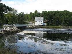 ME Route 175/176 crosses the Bagaduce River | |
| Country | United States |
| Physical characteristics | |
| Main source | Maine |
| River mouth |
Penobscot Bay sea level 44°22′37″N 68°48′50″W / 44.377°N 68.814°WCoordinates: 44°22′37″N 68°48′50″W / 44.377°N 68.814°W |
| Length | 14 miles (23 km) |
The Bagaduce River is a tidal river in the Hancock County, Maine that empties into Penobscot Bay near the town of Castine. From the confluence of Black Brook and the outflow of Walker Pond (44°21′16″N 68°40′41″W / 44.3544°N 68.6781°W), the river runs about 14 miles (23 km)[1] north, northwest, and southwest, forming the border between Brooksville on its left bank and Sedgwick, Penobscot, and Castine on its right.
In 2014, residents of Penobscot raised concerns over the rapidly growing oyster farming on the Bagaduce River.[2]
See also
References
- ↑ U.S. Geological Survey. National Hydrography Dataset high-resolution flowline data. The National Map Archived 2012-04-05 at WebCite, accessed June 22, 2011
- ↑ "Increased oyster farming on the Bagaduce River raises concerns for area residents". Bangor Daily News. Retrieved 4 August 2014.
- "Bagaduce River". Geographic Names Information System. United States Geological Survey. 30 September 1980. Retrieved 2010-05-18.
- Maine Streamflow Data from the USGS
- Maine Watershed Data From Environmental Protection Agency
This article is issued from
Wikipedia.
The text is licensed under Creative Commons - Attribution - Sharealike.
Additional terms may apply for the media files.