Bafing River
_p317_Die_h%C3%A4ngende_Br%C3%BCcke_%C3%BCber_den_Bafing.jpg)
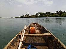
The Bafing River runs through Guinea and Mali and is about 760 kilometres (470 mi) long. It joins with the Bakoy River at Bafoulabé to form the Sénégal River in the Kayes Region of western Mali. In Manding languages, Bafing signifies 'black river' and Bakoye 'white river'.[1][2] The Bafing forms part of the international border between Guinea and Mali.
From 1895 to 1898 the railway bridge near the town of Mahina, designed by Gustave Eiffel, was built.
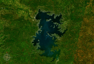
The Manantali hydroelectric dam is located on the Bafing River 90 kilometres (56 mi) upstream of Bafoulabé. It forms the largest artificial lake in Mali, Lake Manantali. The dam retains 11.3 cubic kilometres (2.7 cu mi) of water which is used to power the turbines during the dry season. As a result, the intensity of the maximum flood downstream of the dam has been reduced but during the dry season, a flow of between 150 m3/s (200 cubic yards per second) and 200 m3/s (260 cubic yards per second) is maintained.[3]
References
- ↑ Caractéristiques physiques du fleuve Sénégal (in French), Organisation pour la mise en valeur du fleuve Sénégal, archived from the original on 16 July 2013, retrieved 2 June 2012 .
- ↑ Maïga, Mahamadou (1995), Le bassin du fleuve Sénégal: de la Traite négrière au développement sous-régional autocentré (in French), L'Harmattan, p. 14 footnotes 4, 5 .
- ↑ Étude des impacts environnementaux du projet d’aménagement de Félou (PDF) (in French), Organisation pour la mise en valeur du fleuve Sénégal (O.M.V.S.), 2006, p. 63 .