Gračanica Lake
| Gračanica Lake | |
|---|---|
 | |
| Coordinates | 42°37′24″N 21°14′28″E / 42.6234°N 21.2412°ECoordinates: 42°37′24″N 21°14′28″E / 42.6234°N 21.2412°E |
| Primary inflows | Gračanka river |
| Catchment area | 109 km2 (42 sq mi) |
| Basin countries | Kosovo |
| Max. length | 4.6 km (2.9 mi) |
| Max. width | 0.8 km (0.50 mi) |
| Surface area | 1.7 km2 (0.66 sq mi) |
| Max. depth | 29 m (95 ft) |
| Surface elevation | 655 m (2,149 ft) |
| Islands | 0 |
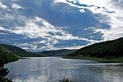
Gračanica Lake or Badovc Lake or Badovac Lake (Albanian: Liqeni i Graçanicës or Liqeni i Badovcit, Serbian Cyrillic: Грачаничко језеро or Бадовачко језеро) is an artificial reservoirs on the river "Gračanka" two kilometers above Gračanica, Kosovo, built in 1963–1966 in order to supply city of Pristina with water. The dam height of 52 m, a width of 246 m, was built in Badovac ravine below Androvac mountains, near the mine "Rainwater".
When it is full, the lake is 3.5 kilometres (2.2 mi) long and up to 500 metres (1,600 ft) wide, maximum depth is 30 m, a total volume of 26 million cubic meters of water. The lake has a catchment area of 109 km2 (42 sq mi).[1] In February 2014, water levels were threatened, due to a very dry winter.[2]
During its construction displaced the Serbian village of Novo Selo, in Gaza waters of the lake, and Badovac, below the dam. With them were sunken remains of the old church of St. Archangel Church and cemetery in Novo Selo.
See also
References
- ↑ Avdullahi, Fejza, Tmava. "Protecting water resources from pollution in the Lake Badovac". INTERNATIONAL JOURNAL OF ENERGY AND ENVIRONMENT. 3 (4): 567–576. ISSN 2076-2895.
- ↑ "Winter Drought Threatens Kosovo Capital's Water". 21 February 2014. Retrieved 21 January 2015.
External links
| Wikimedia Commons has media related to Gračanica Lake. |