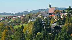
Bad Kreuzen
| Bad Kreuzen | ||
|---|---|---|
 Bad Kreuzen | ||
| ||
 Bad Kreuzen Location within Austria | ||
| Coordinates: 48°16′00″N 14°48′23″E / 48.26667°N 14.80639°ECoordinates: 48°16′00″N 14°48′23″E / 48.26667°N 14.80639°E | ||
| Country | Austria | |
| State | Upper Austria | |
| District | Perg | |
| Government | ||
| • Mayor | Manfred Nenning (ÖVP) | |
| Area | ||
| • Total | 39.9 km2 (15.4 sq mi) | |
| Elevation | 474 m (1,555 ft) | |
| Population (14 June 2016)[1] | ||
| • Total | 2,329 | |
| • Density | 58/km2 (150/sq mi) | |
| Time zone | UTC+1 (CET) | |
| • Summer (DST) | UTC+2 (CEST) | |
| Postal code | 4362 | |
| Area code | 07266 | |
| Vehicle registration | PE | |
| Website | www.bad-kreuzen.at | |

Bad Kreuzen is a municipality in the district Perg in the Austrian state of Upper Austria.
Geography
Bad Kreuzen lies 7 km north of the Danube near Grein. About 29 percent of the municipality is forest, and 65 percent is farmland.
References
| Wikimedia Commons has media related to Bad Kreuzen. |
This article is issued from
Wikipedia.
The text is licensed under Creative Commons - Attribution - Sharealike.
Additional terms may apply for the media files.