Back River (Nunavut)
| Back River | |
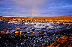
.jpg) Rock garden on the Back River in July 2006 | |
| Name origin: Named after George Back | |
| Country | Canada |
|---|---|
| Territories | Nunavut, Northwest Territories |
| Source | Unnamed lake |
| - location | North Slave Region, Northwest Territories |
| - elevation | 382 m (1,253 ft) |
| - coordinates | 64°29′11″N 108°13′54″W / 64.48639°N 108.23167°W |
| Mouth | Chantrey Inlet, Arctic Ocean |
| - location | Kitikmeot Region, Nunavut |
| - elevation | 0 m (0 ft) |
| - coordinates | 67°16′00″N 95°15′00″W / 67.26667°N 95.25000°WCoordinates: 67°16′00″N 95°15′00″W / 67.26667°N 95.25000°W |
| Length | 974 km (605 mi) |
| Basin | 106,500 km2 (41,120 sq mi) |
| Discharge | |
| - average | 612 m3/s (21,613 cu ft/s) |
 Back River mouth location in Canada | |
| [1][2] | |
The Back River (Dogrib: Thlewechodyeth,[3] Inuktitut: Haningayok,[4] or Great Fish River) is a river in the Northwest Territories and Nunavut in Canada. It rises at an unnamed lake in the North Slave Region of the Northwest Territories and flows more than 974 kilometres (605 mi)[5] mostly through Kivalliq Region, Nunavut, to its mouth at the Arctic Ocean in the Kitikmeot Region of Nunavut.
Course
The river begins at the outflow of an unnamed lake at an elevation of 382 metres (1,253 ft) and flows west into Sussex Lake, then north to Muskox Lake, at the border between the Northwest Territories and Kivalliq Region, Nunavut, where it takes in the left tributary Icy River. It flows over the Muskox Rapids, takes in the left tributary Contwoyto River, and heads east through the Heywood Range. The Back River heads over the Malley Rapids, takes in the left tributary Siorak River and enters the long lake-expansion Beechey Lake in a southeast direction.It heads east, takes in the right tributary Baillie River, left tributary Warren River, right tributary Jervoise River, passes over the Hawk Rapids, takes in the right tributary McKinley River and right tributary Consul River. Between the Baillie and Consul Rivers, the Back River forms the northern border of the Thelon Wildlife Sanctuary.[6] The river turns northeast, takes in the left tributary Bullen River, and reaches Pelly Lake at an elevation of 155 metres (509 ft). It flows east through, in immediate succession: Upper Garry Lake, where it takes in the right tributary Morse River; Garry Lake; Lower Garry Lake; Buliard Lake; Upper MacDougall Lake; and Lower MacDougall Lake. The Back River then heads over the Rock Rapids, Sinclair Falls, Escape Rapids, Sandhill Rapids, and Wolf Rapids, and takes in the right tributary Meadowbank River. The river curves around Mount Meadowbank, takes in the right tributary Hermann River and left tributary Montresor River, passes McKay Peak, heads over the Whirlpool Rapids, and reaches Franklin Lake. It continues northeast, takes in the right tributary Mistake River, passes north into Kitikmeot Region, takes in the right tributary Hayes River (Nunavut) and reaches its mouth at Cockburn Bay on Chantrey Inlet on the Arctic Ocean.[3]
Watershed
The river has a watershed of 106,500 square kilometres (41,120 sq mi)[5] and a mean discharge of 612 cubic metres (21,613 cu ft) per second.[3] The river is 974 kilometres long to the Muskox Lake outlet,[5] though the river continues further upstream to its source.
Like the Coppermine, Hood, Dubawnt or Kazan, which are other large rivers in this part of Canada, it is navigable only by experienced canoeists because of the numerous and challenging 83 rapids.
History
The Back River is the historic homeland of the Haningayogmiut (or Hanningajurmiut) Copper Inuit, also referred to as the Ualininmiut by their Caribou Inuit northern neighbors, the Utkusiksalinmiut.[8] The Kaernermiut (also Kainermiut) and the southerly Ahiagmiut of the Copper Inuit also frequented this area. The Back River and Thelon River were also the northern and northeastern edges of the tribal territories of the enemy Yellowknives and Chipewyan to the south.
Its first exploration by Europeans was led by George Back in 1834,[3] as part of an expedition initially mounted to seek the 1829 expedition of Captain John Ross.[9] Back learned of the river from local guides, and throughout his memoir of the expedition he referred to the river as the "Thlew-ee-cho-dezeth", which he translated as "Great Fish River".[9] Later 19th century explorers habitually referred to the river as "Back's Great Fish River", but gradually this was shortened to "Back River" over time.[10]
On abandoning their ships to the ice, the remaining members of Sir John Franklin's 1845 expedition to map a North-West Passage set out for the Back River but did not survive[11]. In search of them, James Anderson and James Stewart of the Hudson's Bay Company descended the river in 1855 to Chantry Bay and Montreal Island (Nunavut). After a hiatus of slightly over 100 years, it was again descended in 1962 by two groups. One a British group of four young men and the other a group of four young Americans. The British group was led by Robert Cundy who wrote a book about their descent called Beacon Six, and the Americans were led by Austin Hoyt. The Americans started at the source of the River, Sussex Lake, with two Cedar Canvas canoes and reached the coast before the British team. Robert Cundy's group started lower down on Beechey Lake and were overtaken by the Americans. The British were paddling three foldup kayaks, one of which was destroyed on the expedition. Both groups filmed the trip and the British film, Beacon Six, was shown on TV by the Canadian Broadcasting Corporation.
Natural history
The area around the river is full of wildlife, with many fish in the river, and caribou, muskoxen, wolves in the area, with occasional sightings of brown bears, wolverines and Arctic hares. Polar bears are also found as the river nears the Arctic Ocean. The Middle Back River Important Bird Area, located on the river in the Pelly Lake to Lower Garry Lake segment, is a significant habitat for Canada geese, the lesser snow goose and other waterfowl.[12]
Like other areas in Northern Canada, Back River is subject to very cold weather and a persistent Arctic wind that gusts up to gale force.
Modern canoeing
The Back River constitutes a long and difficult voyage,[13] taking over a month of hard work by strong and experienced Arctic (duo) canoeists. The Back is much more challenging than either the Kazan river or the Dubawnt river. Many rapids end in dense "rock gardens" rendering portaging often mandatory. Such portages must be conducted on bare rocks and occasionally unstable boulders. The need for portage is generally lower after a set of rapids known as the "Escape Rapids", thereafter very many rapids (but not all) can be run, as the river becomes less rocky and risky. Water level permitting, two further areas of runable rapids are notable: Sandhill rapids generally navigated on the left bank, Wolf rapids on the right.
Bear repellent spray is recommended as a protection against polar bears on stretches of the river near the Arctic Ocean. Cooking fuel must also be brought in, as the river is above the tree line, and all vegetation is low-lying and not suitable for use as fuel.
The source of the river can be reached by floatplane from Yellowknife, N.W.T. At the end of the trip, a bush plane can be called in from Baker Lake in Nunavut for a landing in a prearranged spot in the tundra.(One must make sure that a rigid canoe can be attached to the exterior of the bush plane. If not, a foldable canoe should be used instead of a rigid one).
The river can also be travelled to its end, where a boat tow can be arranged to the Inuit community of Gjoa Haven, which has bi-weekly commercial air service back to Yellowknife. If planning a canoeing trip on the river, due to the weather, it is generally recommended to have navigated Garry Lake by August 8, the mark of the seasonal change to worse weather. It needs to be noted that being windbound can happen at any time. Due to the proximity to the Arctic Circle and the associated cold, any capsizing can easily conclude in hypothermia and death. A spraydeck-equipped canoe is strongly recommended both for lakes and rapids.
Gallery
 Head of the Escape Rapids, August 2006 |
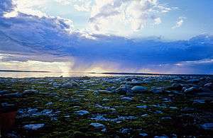 A view on Garry Lake |
Tributaries
- Hayes River (right)
- Mistake River (right)
- Hermann River (right)
- Meadowbank River (right)
- Bullen River (left)
- Consul River (right)
- McKinley River (right)
- Jervoise River (right)
- Warren River (left)
- Baillie River (right)
- Siorak River (left)
- Contwoyto River (left)
- Icy River (left)
See also
References
| Wikisource has the text of the 1911 Encyclopædia Britannica article Back's River. |
- ↑ "Natural Resources Canada-Canadian Geographical Names (Back River)". Retrieved 2014-08-29.
- ↑ "Atlas of Canada Toporama". Retrieved 2014-08-29.
- 1 2 3 4 Marsh, James. "Back River". The Canadian Encyclopedia. The Historica Dominion Institute. Retrieved 2010-08-05.
- ↑ Stefansson, Vilhjalmur (1914). The Stefánsson-Anderson Arctic Expedition of the American Museum: Preliminary Ethnological Report. New York: The Trustees of the American Museum. p. 50. OCLC 13626409.
- 1 2 3 "Rivers Flowing Into the Arctic Ocean - Other Rivers". Atlas of Canada. Natural Resources Canada. 2009-08-17. Retrieved 2010-08-05.
- ↑ Currie, Douglas C; Giberson, Donna; Adler, Peter H (Fall 2002). "Insect biodiversity in the Thelon Wildlife Sanctuary". Newsletter of the Biological Survey of Canada (Terrestrial Arthropods). 21 (2).
- ↑ "James Anderson" (PDF). ucalgary.ca. Retrieved 2008-01-23.
- ↑ "Inuit Heritage Centre". virtualmuseum. Archived from the original on 2008-03-06. Retrieved 2008-01-22.
- 1 2 Back, George (1836). Narrative of the Arctic Land Expedition to the Mouth of The Great Fish River and Along the Shores of the Arctic Ocean, in the Years 1833, 1834, and 1835. London: John Murray.
- ↑ Tews, Jörg (2005). "Back River". In Nuttall, Mark. Encyclopedia of the Arctic. New York: Routledge. p. 185. ISBN 0-203-99785-9.
- ↑ Jonathan Dore, "Franklin Fever", Times Literary Supplement, 23 September 2016, p. 23: reviewing Russell A Potter's Finding Franklin (McGill).
- ↑ "Middle Back River". Important Bird Area Canada. Bird Studies Canada. Archived from the original on 2011-06-12. Retrieved 2010-08-06.
- ↑ Le Guide complet du canotage, Nicolas Perrault, Broquet inc. 2009, p. 190.
- "Back River". Geographical Names Data Base. Natural Resources Canada. Retrieved 2010-08-05.
- "Topographic Map sheets 56L, 56M, 66E, 66F, 66G, 66H, 66I, 66J, 76B, 76C, 76G, 76H". Atlas of Canada. Natural Resources Canada. 2010-02-04. Archived from the original on 3 August 2010. Retrieved 2010-08-05.