Bütschwil-Ganterschwil
| Bütschwil-Ganterschwil | ||
|---|---|---|
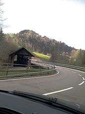
_137.JPG) Bütschwil village | ||
| ||
 Bütschwil-Ganterschwil | ||
|
Location of Bütschwil-Ganterschwil 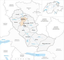 Bütschwil-Ganterschwil Bütschwil-Ganterschwil (Canton of St. Gallen) | ||
| Coordinates: 47°21′N 9°4′E / 47.350°N 9.067°ECoordinates: 47°21′N 9°4′E / 47.350°N 9.067°E | ||
| Country | Switzerland | |
| Canton | St. Gallen | |
| District | Toggenburg | |
| Area[1] | ||
| • Total | 21.83 km2 (8.43 sq mi) | |
| Elevation | 610 m (2,000 ft) | |
| Highest elevation (Sedelberg) | 942 m (3,091 ft) | |
| Lowest elevation (Thur River) | 555 m (1,821 ft) | |
| Population (Dec 2017[2]) | ||
| • Total | 4,729 | |
| • Density | 220/km2 (560/sq mi) | |
| Postal code | 9606 / 9608 | |
| SFOS number | 3395 | |
| Surrounded by | Ganterschwil, Krinau, Lichtensteig, Lütisburg, Mosnang, Oberhelfenschwil, Wattwil | |
| Website |
www SFSO statistics | |

Bütschwil-Ganterschwil is a municipality in the Wahlkreis (constituency) of Toggenburg in the canton of St. Gallen in Switzerland. On 1 January 2013 the former municipalities of Bütschwil and Ganterschwil merged to form the new municipality of Bütschwil-Ganterschwil.[3]
History
Bütschwil is first mentioned in 779 as Bucinesvilare.[4]
Ganterschwil is first mentioned in 779 as Cantrichesuilare.[5]
Geography
The former municipalities that now make up Bütschwil-Ganterschwil have a total combined area of 21.83 km2 (8.43 sq mi).[1]
Bütschwil had an area, as of 2006, of 13.7 km2 (5.3 sq mi). Of this area, 66.3% is used for agricultural purposes, while 19.8% is forested. Of the rest of the land, 12.4% is settled (buildings or roads) and the remainder (1.5%) is non-productive (rivers or lakes).[6] The former municipality is located along the Thur river. On the left bank of the Thur, it consists of the linear villages of Bütschwil and Dietfurt and the hamlets of Grämigen, Tierhag, Feld, Kengelbach and Zwiselen. While on the right bank are the hamlets of Langensteig and Laufen.
Ganterschwil had an area, as of 2006, of 8.1 km2 (3.1 sq mi). Of this area, 63.8% is used for agricultural purposes, while 26.2% is forested. Of the rest of the land, 7% is settled (buildings or roads) and the remainder (3%) is non-productive (rivers or lakes).[6] The former municipality is located on a high plateau between the Thur and Neckar rivers. It consists of the village of Ganterschwil and the hamlets of Äwil, Anzenwil, Bleiken, Ötschwil and Tobel as well as scattered individual farm houses.
Demographics
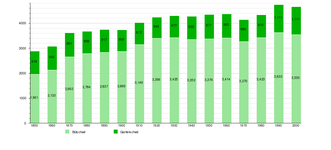
The total population of Bütschwil-Ganterschwil (as of December 2017) is 4,729.[2]
Historic Population
The historical population is given in the following chart:[7]
Sights
The village of Bütschwil is designated as part of the Inventory of Swiss Heritage Sites.[8]
References
- 1 2 Arealstatistik Standard - Gemeindedaten nach 4 Hauptbereichen
- 1 2 Swiss Federal Statistical Office - STAT-TAB, online database – Ständige und nichtständige Wohnbevölkerung nach institutionellen Gliederungen, Geburtsort und Staatsangehörigkeit (in German) accessed 17 September 2018
- ↑ Amtliches Gemeindeverzeichnis der Schweiz published by the Swiss Federal Statistical Office (in German) accessed 2 January 2013
- ↑ Bütschwil in German, French and Italian in the online Historical Dictionary of Switzerland.
- ↑ Ganterschwil in German, French and Italian in the online Historical Dictionary of Switzerland.
- 1 2 Swiss Federal Statistical Office Archived January 5, 2016, at the Wayback Machine. accessed 14 January 2013
- ↑ Federal Statistical Office STAT-TAB Bevölkerungsentwicklung nach Region, 1850-2000 Archived March 17, 2012, at the Wayback Machine. (in German) accessed 29 January 2011
- ↑ ISOS site accessed 12-Jan-2010
External links
| Wikimedia Commons has media related to Bütschwil-Ganterschwil. |
- Bütschwil in German, French and Italian in the online Historical Dictionary of Switzerland.
- Ganterschwil in German, French and Italian in the online Historical Dictionary of Switzerland.