Bézenac
| Bézenac | |
|---|---|
 | |
 Bézenac Location within Nouvelle-Aquitaine region  Bézenac | |
| Coordinates: 44°50′40″N 1°05′28″E / 44.8444°N 1.0911°ECoordinates: 44°50′40″N 1°05′28″E / 44.8444°N 1.0911°E | |
| Country | France |
| Region | Nouvelle-Aquitaine |
| Department | Dordogne |
| Arrondissement | Sarlat-la-Canéda |
| Canton | Vallée Dordogne |
| Area1 | 4.16 km2 (1.61 sq mi) |
| Population (2008)2 | 128 |
| • Density | 31/km2 (80/sq mi) |
| Time zone | UTC+1 (CET) |
| • Summer (DST) | UTC+2 (CEST) |
| INSEE/Postal code | 24041 /240220 |
| Elevation |
57–267 m (187–876 ft) (avg. 120 m or 390 ft) |
|
1 French Land Register data, which excludes lakes, ponds, glaciers > 1 km2 (0.386 sq mi or 247 acres) and river estuaries. 2 Population without double counting: residents of multiple communes (e.g., students and military personnel) only counted once. | |
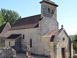
Bézenac (Occitan: Besenac) is a former commune in the Dordogne department in southwestern France. On 1 January 2017, it was merged into the new commune Castels et Bézenac.[1]
Population
| Historical population | ||
|---|---|---|
| Year | Pop. | ±% |
| 1962 | 166 | — |
| 1968 | 167 | +0.6% |
| 1975 | 137 | −18.0% |
| 1982 | 169 | +23.4% |
| 1990 | 117 | −30.8% |
| 1999 | 129 | +10.3% |
| 2008 | 128 | −0.8% |
See also
References
- ↑ Arrêté préfectoral 29 June 2016 (in French)
External links
| Wikimedia Commons has media related to Bézenac. |
This article is issued from
Wikipedia.
The text is licensed under Creative Commons - Attribution - Sharealike.
Additional terms may apply for the media files.