Bära
| Bära | |
|---|---|
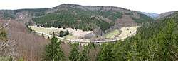 View of the Bära looking northwest from the ruins of Castle Kreidenstein | |
| Country | Germany |
| Location | Baden-Württemberg |
| Physical characteristics | |
| Main source |
Obere Bära in Tieringen Untere Bära at Gosheim 833 m (2,733 ft) |
| River mouth |
In Fridingen into the Danube 623 m (2,044 ft) 48°01′44″N 8°56′04″E / 48.0289°N 8.9345°ECoordinates: 48°01′44″N 8°56′04″E / 48.0289°N 8.9345°E |
| Length | 26.5 km (16.5 mi) [1] |
| Basin features | |
| Progression | Danube→ Black Sea |
The Bära is a river in Baden-Württemberg, Germany. The Bära is a tributary of the Danube, and originates at the confluence of the Obere Bära (Upper Bära) and the Untere Bära (Lower Bära). The 12.7 kilometres (7.9 mi) Bära, together with the Lower Bära, which is longer and has a larger drainage basin, has a combined length of 26.5 kilometres (16.5 mi).
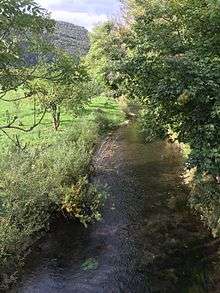
Obere and Untere Bära join to form the Bära in the Galgenwiesen ("gallows meadow"), about four kilometers above the resort of Bärenthal. This runs moderately without significant inflow a further 12.7 kilometres (7.9 mi) south-southeast in Talschlingen, draining an additional area of 31.2 square kilometres (12.0 sq mi). Passing through Bärenthal at last it flows into Fridingen and there, near the town mill, it flows last of all in a southwesterly direction into the upper Danube, approximately at the entrance to the Fridingen Danube Bend.
See also
References
External links
