Avre (Somme)
| Avre | |
|---|---|
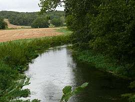 The Avre at La Neuville-Sire-Bernard | |
| Country | France |
| Physical characteristics | |
| Main source |
Amy, Oise 280 m (920 ft) |
| River mouth |
Somme 49°53′0″N 2°20′25″E / 49.88333°N 2.34028°ECoordinates: 49°53′0″N 2°20′25″E / 49.88333°N 2.34028°E |
| Length | 66 km (41 mi) |
| Discharge |
|
| Basin features | |
| Progression | Somme→ English Channel |
| Basin size | 1,150 km2 (440 sq mi) |
The Avre is a river in Picardie and is the principal tributary, from the left side, of the Somme. At 66 kilometres long, it drains a relatively important basin of 1,150 km² but only flows at best 5,1 m³/s near its confluence at Longueau.[1]
Its principal tributaries are: the Noye, joining at Boves, the Trois Doms joining at Pierrepont-sur-Avre, the Brache joining at Braches and the Luce at Berteaucourt-les-Thennes.
References
- ↑ L'Avre sur le site de l'agence de l'eau Artois-Picardie. Archived October 14, 2007, at the Wayback Machine.
This article is issued from
Wikipedia.
The text is licensed under Creative Commons - Attribution - Sharealike.
Additional terms may apply for the media files.