Auslikon
| Auslikon | |
|---|---|
| Former municipality of Switzerland | |
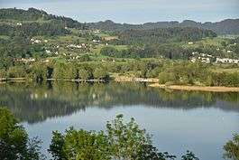 Auslikon aus seen from the Jucker Farm in Seegräben | |
 Auslikon | |
|
Location of Auslikon
Sorry no file found, please edit the map section of the infobox with the correct map image file name. Auslikon Auslikon (Canton of Zurich) | |
| Coordinates: 47°20.6′N 8°48.4′E / 47.3433°N 8.8067°ECoordinates: 47°20.6′N 8°48.4′E / 47.3433°N 8.8067°E | |
| Country | Switzerland |
| Canton | Zurich |
| District | Pfäffikon |
| Municipality | Pfäffikon |
| Elevation | 567 m (1,860 ft) |
| Population | |
| • Total | 350 |
| Postal code | 8331 |
| Surrounded by | Irgenhausen, Kempten, Wetzikon |
| Website |
www |
Auslikon is a village (de:Aussenwacht) of the municipality of Pfäffikon in the canton of Zurich in Switzerland.

Auslikon lido
Geography
Auslikon is located in the district of Pfäffikon in the Zürcher Oberland on the eastern shore of the Pfäffikersee (Lake Pfäffikon).
Demographics
Auslikon belongs politically to the municipality of Pfäffikon.
Points of interest
In Auslikon is a popular Lido and a camping site, within the nature reserve on the Pfäffikersee lake shore, situated.[1]
References
- ↑ Strandbad Auslikon (in German)
External links
| Wikimedia Commons has media related to Auslikon. |
- Official website of the municipality of Pfäffikon (ZH) (in German)
- Dorfverein Auslike-Balm (in German)
This article is issued from
Wikipedia.
The text is licensed under Creative Commons - Attribution - Sharealike.
Additional terms may apply for the media files.