Aurach (Ager)
| Aurach | |
|---|---|
 | |
| Country | Austria |
| Physical characteristics | |
| River mouth |
Ager 48°00′20″N 13°44′16″E / 48.0055°N 13.7377°ECoordinates: 48°00′20″N 13°44′16″E / 48.0055°N 13.7377°E |
| Length | 28.6 km (17.8 mi) [1] |
| Basin features | |
| Progression | Ager→ Traun→ Danube→ Black Sea |
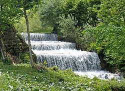
Aurach is a river in the Austrian state of Upper Austria.
It originates from the mountain Hochleckengebiet in the Höllengebirge and flows through the wooden rich valley Aurachtal, that spreads through the communities of Altmünster (Neukirchen, Reindlmühl) and Pinsdorf (Kufhaus). After passing through Aurachtal the river flows further through the Alpenvorland via Aurachkirchen (district of Ohlsdorf) until Wankham (municipality Regau), where it confluences with the river Ager.
References
- ↑ DORIS Atlas (Upper Austria)
External links

This article is issued from
Wikipedia.
The text is licensed under Creative Commons - Attribution - Sharealike.
Additional terms may apply for the media files.