Ager (river)
| Ager | |
|---|---|
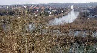 The Ager (right, coming from the west) flowing into the Traun (middle, coming from the south). | |
| Country | Austria |
| Physical characteristics | |
| Main source |
Attersee 47°56′56″N 13°35′36″E / 47.9489°N 13.5934°E |
| River mouth |
Traun 48°05′16″N 13°51′32″E / 48.08778°N 13.85889°ECoordinates: 48°05′16″N 13°51′32″E / 48.08778°N 13.85889°E |
| Length | 33.8 km (21.0 mi) [1] |
| Basin features | |
| Progression | Traun→ Danube→ Black Sea |
The Ager is a river in Upper Austria; it is the discharge of the Attersee between Schörfling am Attersee and Seewalchen, and by Lambach it flows into the Traun.
The Ager emerged towards the end of the Würm glaciation, when the mighty glaciers began to melt.
Influx into the Ager:
- The Vöckla flows into the Ager by Vöcklabruck
- The Aurach flows into the Ager by Wankham
- The Redlbach flows into the Ager shortly before Schwanenstadt
Over the Attersee the Ager also receives water from the Mondsee, the Zeller See (Irrsee), and the Fuschlsee, that are all connected by relatively short streams.
In the postwar period, the Ager was strongly polluted by various nearby factories. Today this is less the case because several sewage treatment plants have been created.
References
- ↑ DORIS Atlas (Upper Austria)
External links

This article is issued from
Wikipedia.
The text is licensed under Creative Commons - Attribution - Sharealike.
Additional terms may apply for the media files.