Aukrasanden
| Aukrasanden | |
|---|---|
| Village | |
 | |
 Aukrasanden Location in Møre og Romsdal  Aukrasanden Aukrasanden (Norway) | |
| Coordinates: 62°47′27″N 06°55′05″E / 62.79083°N 6.91806°ECoordinates: 62°47′27″N 06°55′05″E / 62.79083°N 6.91806°E | |
| Country | Norway |
| Region | Western Norway |
| County | Møre og Romsdal |
| District | Romsdal |
| Municipality | Aukra Municipality |
| Area[1] | |
| • Total | 1.11 km2 (0.43 sq mi) |
| Elevation[2] | 25 m (82 ft) |
| Population (2013)[1] | |
| • Total | 948 |
| • Density | 854/km2 (2,210/sq mi) |
| Time zone | UTC+01:00 (CET) |
| • Summer (DST) | UTC+02:00 (CEST) |
| Post Code | 6480 Aukra |
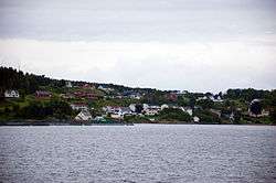
Aukrasanden is a village in Aukra Municipality in Møre og Romsdal county, Norway. The village is located on the southeast side of the island of Gossa, just south of the village of Varhaugvika and the municipal centre of Falkhytta. Just south of Aukrasanden is a ferry connection to Hollingen which is located on the mainland across the Julsundet strait. Aukra Church is located in Aukrasanden. The 1.11-square-kilometre (270-acre) village has a population (2013) of 948, giving the village a population density of 854 inhabitants per square kilometre (2,210/sq mi).[1]
References
- 1 2 3 Statistisk sentralbyrå (1 January 2013). "Urban settlements. Population and area, by municipality".
- ↑ "Aukrasanden" (in Norwegian). yr.no. Retrieved 2010-11-11.
This article is issued from
Wikipedia.
The text is licensed under Creative Commons - Attribution - Sharealike.
Additional terms may apply for the media files.