Augusta Charter Township, Michigan
| Augusta Charter Township, Michigan | |
|---|---|
| Charter township | |
| Charter Township of Augusta | |
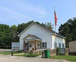 Augusta Township Hall | |
 Augusta Township Location within the state of Michigan | |
| Coordinates: 42°7′38″N 83°36′33″W / 42.12722°N 83.60917°WCoordinates: 42°7′38″N 83°36′33″W / 42.12722°N 83.60917°W | |
| Country | United States |
| State | Michigan |
| County | Washtenaw |
| Area | |
| • Total | 36.7 sq mi (95.2 km2) |
| • Land | 36.7 sq mi (95.2 km2) |
| • Water | 0.0 sq mi (0.0 km2) |
| Elevation | 679 ft (207 m) |
| Population (2010) | |
| • Total | 6,745 |
| • Density | 180/sq mi (71/km2) |
| Time zone | UTC-5 (Eastern (EST)) |
| • Summer (DST) | UTC-4 (EDT) |
| FIPS code | 26-04180[1] |
| GNIS feature ID | 1625863[2] |
| Website |
www |
Augusta Township, officially the Charter Township of Augusta, is a charter township of Washtenaw County in the U.S. state of Michigan. As of the 2010 census, the township population was 6,745.[3]
Communities
- Eaton Mills(Historic) Was originally founded as Conova Corners. It started with a very large sawmill mill in 1850. The mill was ran by the Eaton family. They provided most of the lumber for the plank road from Ypsilanti to Detroit. The planks were cut from the native White Oak and were 9 feet long and 3 inches thick. Eaton Mills had a post office, a wagon shop, two blacksmith,a saloon, two stores and a public school house. Eaton Mills was located near present day Rawsonville and Willis Roads. When the railroad was built in 1881 the town slowly moved to Willis.[4][5]
- Paint Creek(Historic) was a farming settlement. The Indians called it "Wejinigan-sibi" or "Little Crooked Creek"(Ojibway). The village had a stagecoach stop, a post office (founded in 1832), a blacksmith shop, a livery, a sawmill, a hotel with a dance hall on the second floor and a cheese factory on the north side of Willis Road. Paint Creek was located on Willis Rd, on the East Side of Paint Creek, near Tuttle Hill Rd. Tuttle Hill Road was a corduroy road connecting Monroe and Ypsilanti, Michigan. When the railroad was built in 1881 the town slowly moved to Willis.[4][6]
- Willis is an unincorporated community in the northeast corner of the township at 42°09′30″N 83°33′29″W / 42.15833°N 83.55806°W.[7] It is also the name of a post office for the ZIP Code 48191 serving most of the eastern portion of the township. The village was founded in 1881 when the Wabash Railroad built the Detroit to St Louis rail line between Eaton Mills and Paint Creek. The Village's name changed from Willis, to Pottersville to Newcomb, before officially becoming Willis on Dec 15, 1887. The train station operated from 1881 to 1952. The local people donated the materials and built the station themselves in 1881. It was rebuilt after a fire in 1904. Willis used to have a creamery, a grist mill, a pickle factory, several stores, a sawmill, a barber shop and several churches. The first business in the community was Howell's General Store. It was founded in the 1850s and is still in use as Boneheads BBQ Restaurant. Willis still has a small business community that is anchored by the post office that has been here since 1881, Boneheads Restaurant and the Willis Feed Mill.
- Whittaker is an unincorporated community near the center of the township at 42°07′41″N 83°35′59″W / 42.12806°N 83.59972°W.[9] It is also the name of a post office for the ZIP Code 48190 serving the immediate area of the community.[10]
Geography
According to the United States Census Bureau, the township has a total area of 36.7 square miles (95 km2), all land. Stoney Creek Road was called "The Ridge" and is a former boundary of Lake Erie.[4]
Demographics
As of the 2010 census,[11] there were 6,745 people and 2,433 households residing in the township. The population density was 183.6 per square mile (70.9/km²). There were 2,613 housing units at an average density of 71.1 per square mile (27.5/km²). The racial makeup of the township was 86.5% White, 7.8% African American, 0.33% Native American, 0.6% Asian, 0.8% from other races, and 2.3% from two or more races. Hispanic or Latino of any race were 2.1% of the population.
As of the census[1] of 2000, there were 4,813 people, 1,728 households, and 1,384 families residing in the township. The population density was 131.0 per square mile (50.6/km²). There were 1,791 housing units at an average density of 48.7 per square mile (18.8/km²). The racial makeup of the township was 92.2% White, 5.3% African American, 0.3% Native American, 0.2% Asian, 0.1% Pacific Islander, 0.2% from other races, and 1.3% from two or more races. Hispanic or Latino of any race were 0.7% of the population.
There were 1,728 households out of which 34.6% had children under the age of 18 living with them, 68.3% were married couples living together, 7.5% had a female householder with no husband present, and 19.9% were non-families. 16.0% of all households were made up of individuals and 5.8% had someone living alone who was 65 years of age or older. The average household size was 2.77 and the average family size was 3.09.
In the township the population was spread out with 24.9% under the age of 18, 6.9% from 18 to 24, 30.1% from 25 to 44, 27.5% from 45 to 64, and 10.7% who were 65 years of age or older. The median age was 39 years. For every 100 females, there were 101.0 males. For every 100 females age 18 and over, there were 99.4 males.
The median income for a household in the township was $65,033, and the median income for a family was $70,444. Males had a median income of $52,367 versus $31,146 for females. The per capita income for the township was $27,509. About 4.8% of families and 5.4% of the population were below the poverty line, including 1.6% of those under age 18 and 14.2% of those age 65 or over.
Gallery
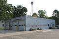 Augusta Twp. Fire Dept.
 Whittaker Post Office
 Whittaker General Store
 Stony Creek Free Will Baptist Church
References
- 1 2 "American FactFinder". United States Census Bureau. Archived from the original on September 11, 2013. Retrieved 2008-01-31.
- ↑ U.S. Geological Survey Geographic Names Information System: Augusta Charter Township, Michigan
- ↑ "Profile of General Population and Housing Characteristics: 2010 Demographic Profile Data (DP-1): Augusta charter township, Washtenaw County, Michigan". U.S. Census Bureau, American Factfinder. Archived from the original on September 11, 2013. Retrieved July 6, 2012.
- 1 2 3 4 Brad Handley, Willis Centennial Keepsake, p. 9
- ↑ Walter Romig, Michigan Place Names, p. 174
- ↑ http://augustatownship.org/history.php
- ↑ U.S. Geological Survey Geographic Names Information System: Willis, Michigan
- ↑ Map of 18191 ZIP Code Tabulation Area
- ↑ U.S. Geological Survey Geographic Names Information System: Whittaker, Michigan
- ↑ Map of 18190 ZIP Code Tabulation Area
- ↑ http://www.semcog.org/Data/Apps/comprof/profile.cfm?cpid=4015
External links
Municipalities and communities of Washtenaw County, Michigan, United States | ||
|---|---|---|
| Cities | 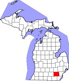 | |
| Villages | ||
| Charter townships | ||
| General law townships | ||
| CDPs | ||
| Unincorporated communities | ||
| Ghost Towns | ||
| Footnotes | ‡This populated place also has portions in an adjacent county or counties | |