Augusta, Indianapolis, Indiana
| Augusta, Indianapolis, Indiana | |
|---|---|
| Neighborhood | |
 | |
 Augusta  Augusta | |
| Coordinates: 39°53′24″N 86°12′43″W / 39.890°N 86.212°WCoordinates: 39°53′24″N 86°12′43″W / 39.890°N 86.212°W | |
| Country | United States |
| State | Indiana |
| County | Marion |
| Township | Pike |
| Time zone | Eastern (EST) |
| ZIP code | 46268 |
| Area code(s) | 317 & 463 |
Augusta is a neighborhood in Pike Township, Marion County, in the U.S. state of Indiana. It was formerly a small village that later had a post office and general stores.[1]
History
Augusta was settled when the Michigan Road was completed. It became a thriving community with a general store and other commercial buildings. In 1852, the Indianapolis & Lafayette Railroad was constructed parallel to and about 1.5 miles (2.4 km) west of Michigan Road and the settlement. Eventually much of the Augusta business community moved to be near the railroad station in what is now New Augusta.[1]
Geography
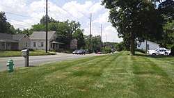
Augusta is located just south of Crooked Creek at the intersection of 76th St. and Michigan Rd. in Indianapolis.[2]
 Intersection of 76th St. and Michigan Rd. in Augusta
See also
References
- 1 2 "New Augusta Historic District". National Park Service. Retrieved July 14, 2017.
- ↑ "Google Maps - Augusta". Retrieved 9 June 2017.
This article is issued from
Wikipedia.
The text is licensed under Creative Commons - Attribution - Sharealike.
Additional terms may apply for the media files.